Rothes – Burn Walk
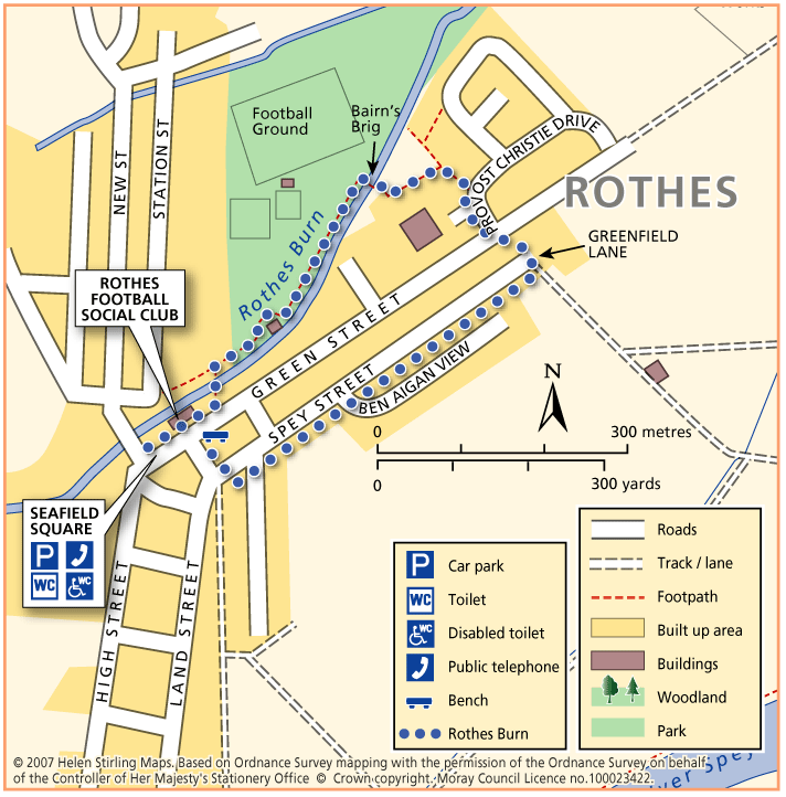
This flat, circular walk follows the Rothes Burn as it passes through the Playing Fields and also includes some great views over the open countryside to Ben Aigen. The surfaces are all good and are suitable for wheelchairs and buggies, although care is needed over the footbridges.
- Accessible Walk, Health Walk
- Easy / Level 1
- 0.75 miles (1.2 km)
- 15 minutes
- Rothes
- Accessible for all users
- Paved footpaths & roads
- Generally level
Report a route change
If you have followed this route and noticed any differences please report a route change by sending an email to:
Send us a GPX track
We would like to offer GPS tracks of all routes on this site.
If you are able to help please create a GPX track of this route (no detours) and send it to us for inclusion.
Start – Seafield Square, Rothes
1. Walk down Green Street, past the Rothes Football Social Club.
2. Take the path to the left by the picket fence and cross the burn, turning right and following the path through the park to the Bairns’ Brig.
3. Cross the burn here and follow the path round the back of the Primary School, bearing right along Provost Christie Drive to the junction with Green Street.
4. Cross over and walk down Greenfield Lane in between the farm buildings.
5 Turn right and walk to the end of Spey Street.
6 Turn right and return to the Square.

