Roseisle Beach
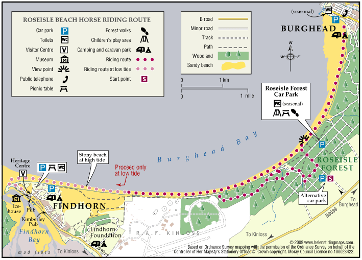
A very pleasant, long beach ride. Roseisle Beach stretches for nearly eight miles from Findhorn in the west to Burghead in the east. The route described is not way-marked or maintained by the Commission as a horse-riding route.
- Horse Ride
- 8 miles (12.8 km)
- Burghead, Findhorn
Terrain: Coastal tracks
Once across the softer sand and gravelly patches the beach sand is good and level and firm although keep an eye out for soft spots/hidden rocks/small 'streams' of water.
- Generally level
- Partly signed
Report a route change
If you have followed this route and noticed any differences please report a route change by sending an email to:
Send us a GPX track
We would like to offer GPS tracks of all routes on this site.
If you are able to help please create a GPX track of this route (no detours) and send it to us for inclusion.
Generally the sand is very firm with excellent going for a good long gallop, though there are a few softer spots, so be prepared to pull up if necessary
Access & Parking: The best access is from the Forestry Commission car-park, about two miles west of the College of Roseisle crossroads on the Kinloss road. It is clearly sign-posted. At busy times of year the Forestry Commission ask that riders do not use the main car park, instead park in either of the paddocks on both sides of the road just after you enter the forest. Always park with consideration for other users and remove all droppings and other litter.
Always check the tide tables as the good sand for riding is only exposed at low tide. It is safest to arrive about three hours after high tide, that way you will be riding as the tide is going out rather than coming in. Tide times are published daily in the P&J and there is a link to the Hydrographic Office website on the ‘Where to ride page’ of the MEAG website. High tide is about an hour later each day so you can easily calculate a few days ahead. At Findhorn the sea can go out for nearly a mile, so be very careful as the tide comes in very fast!
The beach is quite wide and most visitors tend to stay on the beach close to the parking area. Even so there are usually quite a few walkers; give them a wide berth if you can as they often have their dogs off the lead! This is the place to let rip and allow your horse to let off steam – he will run out of puff long before you run out of sand. If he doesn’t then you probably have a Derby winner.
At the Findhorn end you are close to the taxi-way at RAF Kinloss but the planes never seem to be a problem and do not usually fly at weekends.
You will see a lot of seabirds, and if lucky you may even see seals. For the historian, the old wartime defences are of interest and will spice up the ride as horses invariably spook at them!
The car park gets very busy at weekends, especially when the weather is good in the summer so at these times you should park on the access road or in one of the paddocks by the entrance to the forest. At quiet times the main car-park is very pleasant, shady, no flies and with some grass. There are also loos and barbecue sites. From the car-park there are several paths leading to the beach, but elsewhere there are very few places you can get back into the forest. Once in the forest though there is a good network of tracks to explore offering alternative return routes. Definitely a highly recommended day out.
There are some waymarked paths for walkers in the forest and you should avoid using these. Also, the path onto the beach nearest the car-park entrance has facilities for less-able people and should be avoided by riders.

