The Fishwives Route

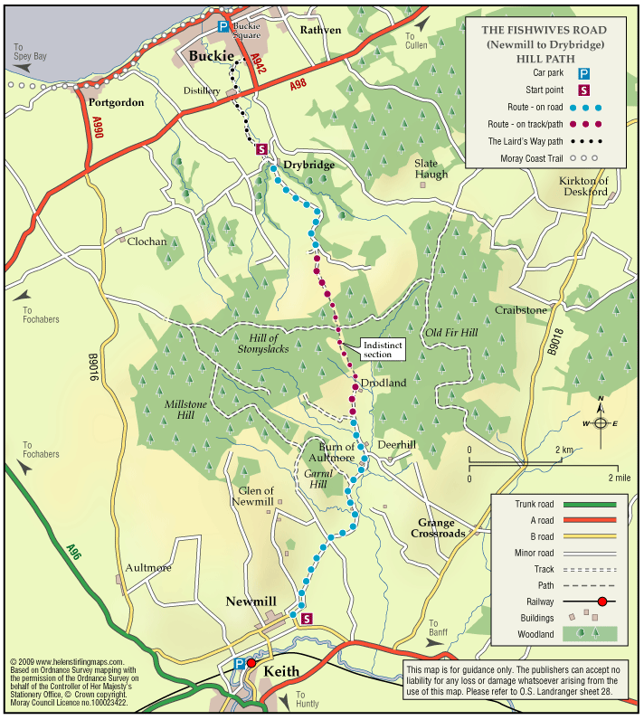
Follow the footsteps of the Fishwives. The Fishwives Path starts at the Buckie & District Fishing Heritage Centre where you will discover the unique fishing history of this lovely part of the Moray Firth.

  • Accessibility: Suitable for a wide range of users

    Suitable for more able and energetic walkers. The off road sections would be of interest to horse riders and mountain bikers.

  • Terrain: Varied surfaces

    Nearly two thirds of the route is along tarmac roads and paths which are easy to negotiate. The rest is on farm/forestry tracks and grassy paths; the surface in places is rough and uneven and can be muddy in wet weather.

  • Gradient: Gentle gradients

    The route climbs from the sea at Buckie to around 270 metres (900ft) above sea level. From both the Keith and Buckie ends the path rises gradually to the highest point at Addie Hill.

  • Barriers: Some barriers

    Gates

  • Fully signed

Elgin – Cooper Park Walk

This is a flat, circular route along paths taking you round Cooper Park, suitable for wheelchairs and buggies. This is a pleasant walk through the Park, on good paths. There are toilets in the Library and the café is open between 10am and 4pm.

  • Accessible for all users
  • Paved footpaths & roads
  • Generally level
  • No barriers
  • Unsigned

The Moray Way

The Moray Way is Moray’s unique long-distance circular route, which follows the Moray Firth coast, crosses over moorland and tracks the river Spey. Few walks can match the range of scenery and wildlife found along the Moray Way. It can be walked comfortably in five to nine days.

Once you have completed the full route, why not claim your free “I WALKED AROUND THE MORAY WAY” certificate and celebrate your achievement by buying a pair of Moray Way socks?

  • Accessibility: Suitable for a wide range of users

    The route is primarily promoted for walking. Sections which make use of old railway lines are suitable for mountain bikes. The beach sections of the Way are ideal for horse riding. Sections of the Speyside Way along the old railway are suitable for horse riding. Cycling and horse riding on other sections of the way is not recommended due to physical condition and consideration for other users.

  • Terrain: Varied surfaces

    There are a wide variety of surface types that make up the route ranging from sandy dunes to minor metalled roads.

  • Gradient: Mixed gradient

    The Moray Coast Trail section is mostly flat with a rougher section between Burghead and Lossiemouth. The Dava Way involves gentle ascent and decent following the old railway line. The Speyside Way is mostly flat where it follows minor roads, tracks and an old railway, but has steep sections at Ben Aigen and near Cromdale.

  • Barriers: Some barriers

    Long sections of the route are free from barriers which would impede access. There are some stiles, gates and short flights of steps along the route. Steps are mostly to be found between Burghead and Lossiemouth and at varying points on the Speyside Way. There are no gates or stiles on the Moray Coast Trail but there are several on the Speyside Way and the Dava Way.

  • Fully signed

The Dava Way (Horse Ride)

This is a long distance route that runs from Forres to Grantown, mostly following the old railway line. It has superb scenery with woods and forests at both ends, extensive heather moorland in the middle and a dramatic valley crossing on a viaduct.

    Cullen – Crannoch Circular Path

    The route provides a variety of views and habitats. Travelling clockwise, the first section east of Cullen provides open views over agricultural land and the coast. The woodland loop provides access to conifer/mixed woodland and freshwater habitats.

    • Suitable for buggies but not wheelchairs
    • Terrain: Varied surfaces

      A mixture of pavements, quiet country roads, and farm tracks, with aggregate and earth paths through the woodland section. These woodland and farm tracks can be muddy in wet weather, and watch out for tree roots within Crannoch Wood. There is a short steep slope at the eastern entrance to the Crannoch Wood circular path, which can be slippy.

    • Gradient: Undulating

      Undulating route with long steady inclines/ declines. One steep section present at the eastern entrance to the Crannoch Wood circular path.

    • Barriers: Some barriers

      Care to be taken when crossing the A98 - this is a very fast and busy road. Several gates leading along the farm track from Cullen to Crannoch Wood.

    • Fully signed

    Forres – Sanquhar Chapelton Muiry

    A circular walk around the southern outskirts of Forres taking in Sanquhar Loch and Woodlands, Cluny Hill and an unexpected glimpse of Findhorn Bay.

    • Unsuitable for wheelchairs and buggies
    • Terrain: Varied surfaces

      Pavements, tarmac and gravel paths. There are also some sections of earth path through the woodland areas.

    • Mixed gradient
    • Barriers: Some barriers

      A sets of steps in Grant Park leading from the car park, a set leading down to Sanquar Loch, and a set at the Mosset Burn near Chapelton.

    • Fully signed

    Lossiemouth – Forest by the Firth Trail 

    The town commands the prominent headland at the mouth of the River Lossie. It has dramatic and beautiful beaches, wonderful countryside and plenty to see and do. Part of the route follows the long-distance Moray Coast Trail. 

    • Accessibility: Unsuitable for wheelchairs and buggies

      Due to the loose sand and shingle, the route is unsuitable for wheelchairs, buggies or road bikes.

    • Terrain: Varied surfaces

      The route follows the sandy beach, with areas of loose shingle, and forest tracks. The trail can also be damp through the salt marsh area. Sturdy footwear is advised.

    • Gradient: Generally level

      Relatively level, except short steep shingle ridge of around 2 metres in height.

    • Barriers: Some barriers

      During high Spring Tides the route may be impassable along the beach. The trail requires a short scramble over a steep section of loose shingle (approx 2 metre height) to the dunes. Access to the beach is over a long narrow timber bridge.

    • Partly signed

    Burghead – Clarkly Hill Circular

    A circular walk starting in the Pictish Fort town of Burghead and passing through farmland and rocky shores, with stunning views of the Moray Firth along the ridge of Clarkly Hill.

    • Unsuitable for wheelchairs and buggies
    • Terrain: Varied surfaces

      Tarred pavements & roads, gravel paths, and earth/grass paths along the Clarkly Hill sections. Note: the earth paths are rough and uneven in places and can be muddy.

    • Gradient: Generally level

      A gentle slope rising from the Burghead - Lossiemouth road to Clarkly Hill

    • Fully signed

    Forres – Mosset Walk

    A circular walk around Forres, taking in the picturesque Sanquhar Loch, the panoramic view from the Nelson Tower at the top of Cluny Hill and a fine view of the town from Councillor’s Walk. 

    • Unsuitable for wheelchairs and buggies
    • Terrain: Paved footpaths & roads

      Take care on the two A96 road crossings.

    • Gradient: Short steep sections

      A fairly steep path within Grant Park leading up to Nelson Tower. Otherwise, generally level with only a few gentle slopes.

    • Barriers: Some barriers

      Kissing Gates (2), and steps.

    • Fully signed

    Keith – Broomhill Circular

    This is a circular walk which includes Broomhill Cemetery. The route includes a beautiful tree lined path and a farm track, which can be quite exposed in bad weather. It is not suitable for wheelchairs or buggies. This route can join up with St Rufus Park Walk by turning right into the park off Broomhill Road.

    • Unsuitable for wheelchairs and buggies
    • Terrain: Varied surfaces

      A combination of roadside pavements, a tarmac footpath through the cemetery and a long section of gravel farm track. Take care on the track which is rather potholed and can be muddy in wet weather.

    • Gradient: Undulating

      Some gentle inclines.

    • Barriers: Some barriers

      Quite heavy gate at Broomhill cemetery.

    Keith – Fife Keith Park

    This is a pleasant circular walk, through town and woodland, including Cottage Wood. There are some long gradual slopes in the walk and the woodland paths need care, especially when wet. It is also fairly exposed in places and is not suitable for wheelchairs or buggies.

    • Unsuitable for wheelchairs and buggies
    • Terrain: Varied surfaces

      A mixture of tarmac pavements, bare earth woodland paths and a country road. Although reasonably quiet, please be vigilant of traffic on the road section.

    • Gradient: Undulating

      A few long gradual slopes.

    • Barriers: Some barriers

      Steps - located at entrance to Cottage Wood.

    Keith – Simpson Memorial Park

    This is a circular walk which takes you round Simpson Memorial Park. It is mostly on pavements and good paths, apart from a short stretch of grass path which could be muddy in the wet. It is suitable for wheelchairs and buggies if dry and is fairly flat apart from the section along Drum Road.

    • Accessibility: Accessible for all with care

      Can be used by buggies and wheelchairs during dry weather.

    • Terrain: Varied surfaces

      Mostly on tarmac pavements and paths. Grass path at Simpson park - which can be muddy in wet weather.

    • Gradient: Undulating

      Long but steady climb up Drum Road. Relatively flat elsewhere.

    Keith – Cuthil Park Circular

    This is a circular walk round Keith, following the little lanes that criss-cross the town. The surfaces are suitable for wheelchairs and buggies and the route is fairly level apart from a steady climb from Turner Street to Cuthill Park. There are benches at the start and at Cuthil Park.

    • Accessible for all users
    • Paved footpaths & roads
    • Gradient: Undulating

      Steady climb from Turner St to Cuthil Park. Relatively level elsewhere.

    Keith – Horse Market Circular

    This is a circular, level walk past fields of horses. There are benches in the Square and 1 along Edindiach Road. Pavements are good and the walk is suitable for wheelchairs and buggies.

    • Accessible for all users
    • Paved footpaths & roads
    • Generally level

    Archiestown – Forest Circular

    This circular walk takes you deep into woodland along tracks which are not suitable for wheelchairs and buggies.

    • Unsuitable for wheelchairs and buggies
    • Terrain: Varied surfaces

      A mixture of bare earth and gravel paths. Surfaces can be muddy in places.

    • Gradient: Undulating

      Some steady inclines and declines.

    • Barriers: Some barriers

      Several narrow bridges/ platform bridges. Tree roots in places.

    Burghead – Railway Path

    This walk takes you from the picturesque harbour in Burghead on a circular route along the old railway track. The surfaces are generally good but not suitable for wheelchairs and buggies. It can be a little exposed if the winds are strong. There are toilets at the harbour and benches on Grant Street.

    • Unsuitable for wheelchairs and buggies
    • Terrain: Varied surfaces

      Gravel paths and tarmac pavements

    • Gradient: Short steep sections

      Fairly steep decline on gravel path between Fraser Road and the coastal path. Elsewhere relatively level with some gentle slopes.

    • Barriers: Some barriers

      Windblown sand can accumulate on a short section of the coastal path, near where it meets the track down from Fraser Road. This may cause difficulties for wheelchairs and some buggies.

    • Partly signed

    Elgin – Town Walk

    The Elgin City Trail has a choice of locations to start from including a number of car parks and the main bus and train stations. Choose your own way of linking the historic features around Elgin.

    • Accessibility: Suitable for a wide range of users

      The nature of this route being primarily on urban tarmac paths adjacent to roads makes it most suitable for walkers and less able users. Riverside Path section could be difficult for the less physically able because of uneven surface and steps.

    • Paved footpaths & roads
    • Generally level
    • Barriers: Some barriers

      Numerous road crossing, dependant upon your chosen route. Most of the main roads have traffic light controlled crossings or designated crossing places. Steps on the Riverside Path Section.

    Ben Rinnes

    Ben Rinnes is the highest freestanding mountain in Moray at 2733ft (841 metres), and is classified as a ‘Corbett’ – a summit lying between 2500ft and 2999ft. 

    • Unsuitable for wheelchairs and buggies
    • Defined hill path
    • Slopes throughout
    • Unsigned

    Elgin – Elgin Experience cycle route

    One of five Circular Cycle Routes in Moray, the ‘Elgin Experience’ takes you on a 13 mile journey through Moray’s Historic capital city and it’s scenic surrounding countryside.

    • Generally level
    • Fully signed

    Buckie – Circular Town Walk

    Although this circular walk is in town, there are excellent views of countryside and over the Moray Firth, making it an enjoyable walk any time of year. The route is along level paved surfaces and it is suitable for wheelchairs and buggies. There are benches and seats along the route.

    • Accessible for all users
    • Paved footpaths & roads
    • Gradient: Undulating

      Slight hill at Douglas Crescent.

    • Unsigned