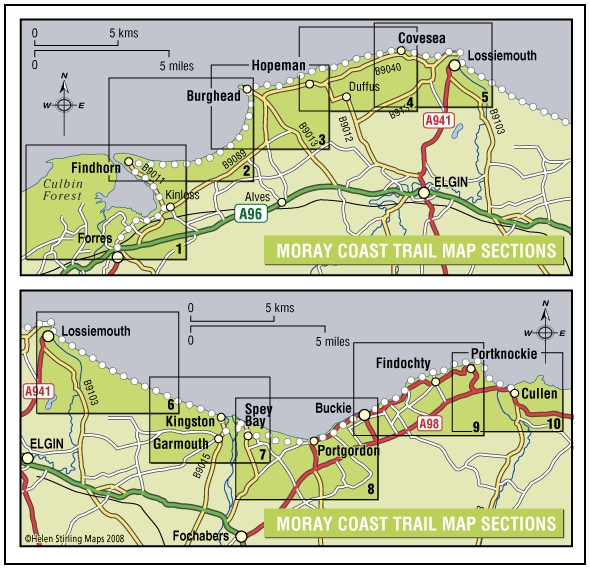
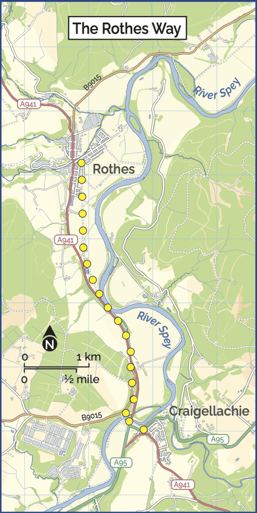
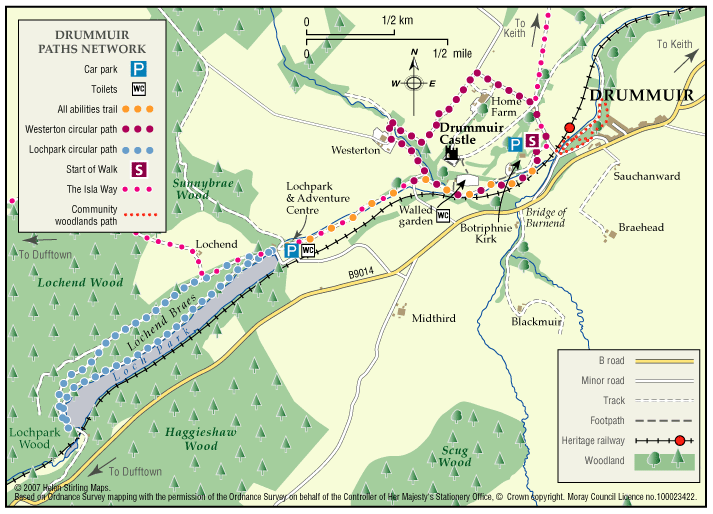
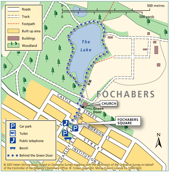
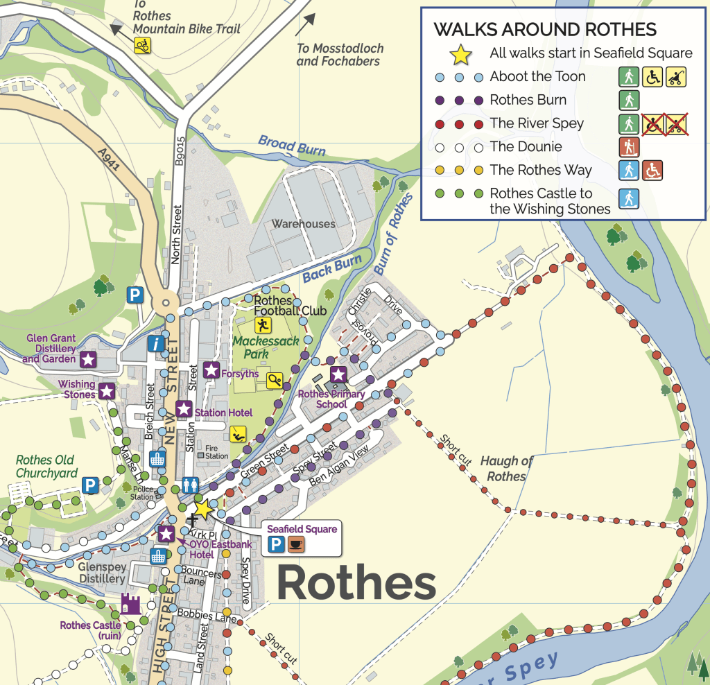
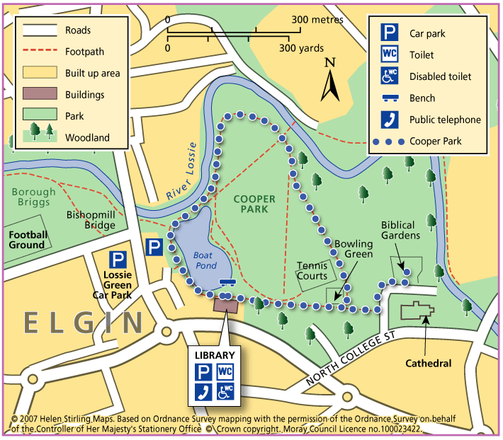
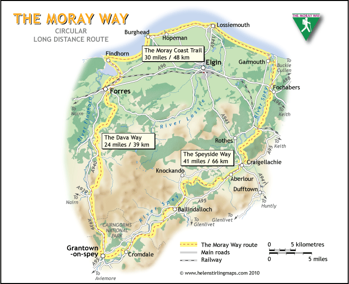
The Moray Way

The Moray Way is Morayโ€™s unique long-distance circular route, which follows the Moray Firth coast, crosses over moorland and tracks the river Spey. Few walks can match the range of scenery and wildlife found along the Moray Way. It can be walked comfortably in five to nine days.

Once you have completed the full route, why not claim your free “I WALKED AROUND THE MORAY WAY” certificate and celebrate your achievement by buying a pair of Moray Way socks?

  • Accessibility: Suitable for a wide range of users

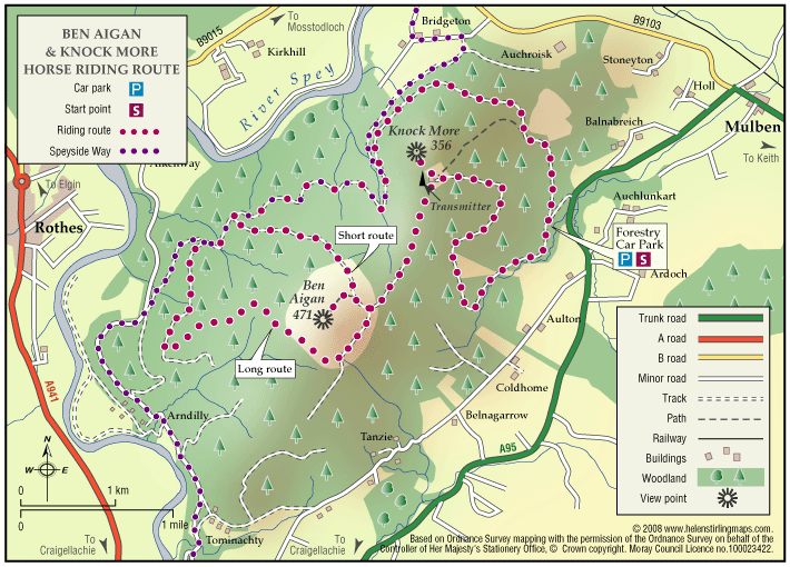
    The route is primarily promoted for walking. Sections which make use of old railway lines are suitable for mountain bikes. The beach sections of the Way are ideal for horse riding. Sections of the Speyside Way along the old railway are suitable for horse riding. Cycling and horse riding on other sections of the way is not recommended due to physical condition and consideration for other users.

  • Terrain: Varied surfaces

    There are a wide variety of surface types that make up the route ranging from sandy dunes to minor metalled roads.

  • Gradient: Mixed gradient

    The Moray Coast Trail section is mostly flat with a rougher section between Burghead and Lossiemouth. The Dava Way involves gentle ascent and decent following the old railway line. The Speyside Way is mostly flat where it follows minor roads, tracks and an old railway, but has steep sections at Ben Aigen and near Cromdale.

  • Barriers: Some barriers

    Long sections of the route are free from barriers which would impede access. There are some stiles, gates and short flights of steps along the route. Steps are mostly to be found between Burghead and Lossiemouth and at varying points on the Speyside Way. There are no gates or stiles on the Moray Coast Trail but there are several on the Speyside Way and the Dava Way.

  • Fully signed

The Moray Coast Trail

The coastline and settlements of Moray are linked by a waymarked coastal trail of approximately 50 miles from Findhorn to Cullen and all the places between. The route can be extended from Findhorn to Forres along a section of cycle route.

  • Accessibility: Suitable for a wide range of users

    Many sections of the route can be used for cycling and horseriding in addition to walking. In wilder locations the path can be steep and rough in places, which would restrict access. Generally the route is most accessible in the vicinity of the coastal settlements. Less able users should concentrate on using these sections.

  • Terrain: Varied surfaces

    There are varied surfaces including tar, gravel and earth paths, with some beach and rock sections. In places the trail follows pavements through the towns and villages, whilst in other areas the route uses rough tracks along the coastal clifftops and forests.

  • Gradient: Generally level

    Generally level with some short steep climbs in places.

  • Barriers: Some barriers

    There are steps and gates in some sections, particularly along the rugged coastline at the Hopeman Ridge and between Buckie and Cullen.The route crosses Lossiemouth and Cullen beaches at low tide, but at high tide you will have to follow an alternative (unsigned) foreshore route.The section between Lossie and Kingston has the military firing range and when in use red flags are hoisted at each corner which prevent users from progressing further, for information on which days the range is being used telephone Fort George on 0131 310 8692.

  • Fully signed

The Rothes Way

A community-led project led to this multi-use path linking Rothes and Craigellachie, being created for everyone to enjoy.

  • Accessibility: Accessible for all with care

    There's a gravel path for the whole route so suitable for all-terrain wheelchairs, buggies and adaptive cycles.

  • Gravel path
  • Generally level
  • Barriers: Some barriers

    Along the route, there are several gates and slow barriers, all of which are passable with care.

  • Unsigned

Tomintoul – Carn Daimh

Cairn Daimh (Hill of the Stags) at 1866ft (570m) is most often ascended in the course of following the Tomintoul Spur of the Speyside Way, between Glenlivet and Tomintoul.

  • Partly signed

Ben Aigan and Knockmore

This ride takes you to the transmitter on Knockmore, the summit of Ben Aigan and stunning views of Speyside. The route described is not way-marked by the Forestry Commission as a horse-riding trail.

  • Terrain: Varied surfaces

    Mostly forest roads, some open moorland and one steep grassy track. The climb to the summit is very stony.

  • Mixed gradient

Drummuir – Paths Network

A suite of trails has been created on the Drummuir Estate developed by Drummuir 21, a local community group. Options exist for walks of approximately 40, 70 or 120 minutes duration depending on your inclination. Ideal for families. Part of the trail system is suitable for wheelchair users (about 3 miles return trip).

  • Accessibility: Accessible for all users

    The all abilities section is suitable for wheelchairs and buggies.

  • Terrain: Gravel path

    Relatively good surfaces throughout; mainly tarmac and gravel paths with a section of quiet public road. The All Abilities Trail section between the Botriphnie Kirk car park and Loch Park follows a level gravel path.

  • Mixed gradient
  • No barriers
  • Fully signed

Fochabers – Behind the Green Door

This is a very picturesque and sheltered circular walk around a lake in the quiet and traffic free grounds of Gordon Castle. It is along a good, narrow track which can be a bit muddy in wet weather so wear appropriate footwear. Children love this walk, remember to take food for the ducks!

  • Accessible for all users
  • Terrain: Gravel path

    Can be muddy when wet.

  • Generally level
  • No barriers

Rothes – Burn Walk

This flat, circular walk follows the Rothes Burn as it passes through the Playing Fields and also includes some great views over the open countryside to Ben Aigen. The surfaces are all good and are suitable for wheelchairs and buggies, although care is needed over the footbridges.

  • Accessible for all users
  • Paved footpaths & roads
  • Generally level
  • Barriers: No barriers

    Take care crossing the footbridges.

  • Unsigned

Elgin – Cooper Park Walk

This is a flat, circular route along paths taking you round Cooper Park, suitable for wheelchairs and buggies. This is a pleasant walk through the Park, on good paths. There are toilets in the Library and the cafรฉ is open between 10am and 4pm.

  • Accessible for all users
  • Paved footpaths & roads
  • Generally level
  • No barriers
  • Unsigned

Cabrach

This is a pleasant and scenic all day ride across open moorland with some good views from the slopes of Cook’s Cairn. Quite a bit of wildlife to see including large herds of deer.

  • Terrain: Varied surfaces

    Some good estate tracks suitable for fast trotting; the higher moorland tracks are rougher and more stony.

Dufftown- The Giant’s Chair

The ‘Giant’s Chair’ is a rock feature carved out by the power of the River Dullan in spate. This lovely walk takes in many interesting features of history, culture and landscape. Dufftown has seven operating whisky distilleries including the famous Glenfiddich brand.

  • Accessibility: Suitable for a wide range of users

    The route is suitable for walkers and mountain bikes.

  • Terrain: Varied surfaces

    Mixture of tarmac, gravel and grass. Some rough sections near The Giant's Chair.

  • Gradient: Undulating

    An undulating path with some short steep sections. Total height climbed is around 200ft (60 metres).

  • Barriers: Some barriers

    Kissing gate at far end of this walk, and some flights of steps

  • Fully signed

Rothes – Spey Walk

This flat, circular walk follows the River Spey on itโ€™s way from Craigellachie to Boat oโ€™ Brig. The path is good but is not suitable for wheelchairs or buggies. The scenery along this walk is very beautiful at any time of year, although it can be a little exposed in places and the paths can be muddy in wet weather.

  • Unsuitable for wheelchairs and buggies
  • Terrain: Varied surfaces

    Mainly grass and earth path, with some sections of farm track and tarmac. Paths can be muddy when wet.

  • Generally level
  • Unsigned

Rothes – The Dounie

This walk follows the Rothes Burn upstream to the Giant’s Table and the Fairy Rock – volcanic outcrops worn and shaped by thousands of years of erosion – and returns by the track skirting the golf course.

  • Unsuitable for wheelchairs and buggies
  • Terrain: Varied surfaces

    Mostly Forest tracks. If you decend via the golf course then the route is by road.

  • Gradient: Short steep sections

    Varying gradients, climbing to 250m.

  • Barriers: Some barriers

    Some steps and occasionally fallen trees.

  • Partly signed

Keith – Denwell / Braehead Circuit

The route can be enjoyed in both directions, starting and finishing at the map information board in Keith Square (Reidhaven Square). As parts of the route cross open countryside and have a variety of path surfaces, stout footwear and waterproof clothing are recommended.

  • Accessibility: Suitable for a wide range of users

    The minor road sections are suitable for people of a wide range of abilities.

  • Terrain: Varied surfaces

    A combination of rough grass paths and sections of minor tarred road.

  • Gradient: Generally level

    A few gentle gradients on the Brandy Brae path.

  • No barriers
  • Fully signed

Tomintoul – Old Military Road

This linear walk follows the old military road out of Tomintoul heading to Alltachbeg. The track is undulating and wide but rutted and muddy in parts, needing sturdy footwear or wellies depending on how wet it is. The views are tremendous though, and worth the effort to see the hills and open heather moorland stretching out before you.

  • Unsuitable for wheelchairs and buggies
  • Terrain: Uneven terrain

    Gravel track - pot holed and can be muddy in wet weather.

  • Undulating
  • No barriers

Aboot The Toon – Rothes

Enjoy a flat, circular walk that loops around the heart of Rothes, taking you past some of the townโ€™s most interesting and historic spots.

  • Accessible for all users
  • Paved footpaths & roads
  • Gradient: Generally level

    Mostly on pavements.

  • No barriers
  • Unsigned

Rothes Castle to Wishing Stones

This walk weaves through the rich heritage of Rothes, taking you to the well-known Rothes Castle, past a local distillery, through the historic Rothes Graveyard and Old Churchyard, and finally to the lesser-known but intriguing Wishing Stones โ€” a hidden gem with no backstory! Rothes Rambles The Rothes Rambles leaflet is a wonderful celebration of …

  • 1.1 miles (1.76 km)
  • 30 minutes
  • Accessibility: Suitable for buggies but not wheelchairs

    There are steep sections and sections with steps.

  • Terrain: Varied surfaces

    Paths and pavements

  • Gradient: Undulating

    Steep slopes and paths.

  • Barriers: Many barriers

    Bridge and steps.

Balloch Wood and Hill

The Balloch forest covers about 2,500 acres and has a network of forest roads so a variety of routes are possible.ย  At the southwest end you can follow part of Governor Caulfeildโ€™s military road, built about 1750, which ran from Stonehaven to Fochabers.

    Forres – Engineering Past and Present

    An interesting and varied circular walk on the outskirts of Forres which visits some of the engineering projects that have changed the local landscape from the 19th century to the present day.

    • Suitable for a wide range of users
    • Terrain: Varied surfaces

      Mixture of tarmacked paths, stepped sections, woodland tracks and earth paths with some undulating sections.

    • Generally level
    • Barriers: Some barriers

      There are a few stepped sections and two wooden bridge crossings over the Burn o' Mosset.

    • Unsigned