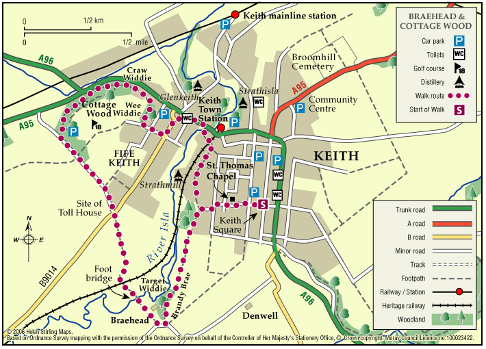
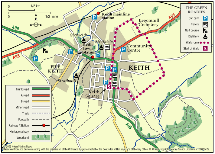
Keith – Dunnyduff and The Den

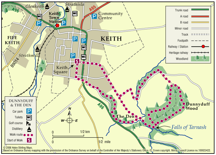
This walk is part of a network of waymarked and signed paths linking all the delights the Keith area has to offer. The route can be enjoyed in both directions, starting and finishing at the map information board in Keith Square (Reidhaven Square).ย 

  • Accessibility: Unsuitable for wheelchairs and buggies

    Suitable for a wide range of users in the flat sections near Keith but in the countryside the route is appropriate for more able, energetic persons. Horse riding is not recommended at Tarnash due to the steep nature of the path linking to Dunnyduff.

  • Terrain: Varied surfaces

    A combination of roadside pavements, minor roads, green tracks and some rougher paths with several steep inclines.

  • Short steep sections
  • Barriers: Some barriers

    Some steps exist in Dunnyduff Wood.

  • Fully signed

Forres – Nelson’s Monument Walk

This is a circular walk through woodland on good paths with some steady climbs and descents. The paths can be muddy or full of leaves depending on weather conditions and time of year. The view from the top of the hill is spectacular. The Tower is open between Tuesday to Sunday from 2pm – 4pm during May and September. If you can manage the stairs, on a clear day you can see Findhorn Bay and over the Moray Firth to the hills of Easter Ross and Sutherland.

  • Unsuitable for wheelchairs and buggies
  • Terrain: Varied surfaces

    Tarmac and gravel footpaths - can be muddy.

  • Undulating

Forres – Roysvale Park

This is a flat circular route, all on pavements so suitable for wheelchairs and buggies. The Sensory Garden in Orchard Road is worth a short stop to smell the aromatic plants. There is a bench there and also one in front of the Leisure Centre. You can extend this walk to include Sanquhar Loch.

  • Accessible for all users
  • Paved footpaths & roads
  • Generally level
  • No barriers

Moray Coastal Cycle Route

This is a signed cycle route from Burghead to Cullen, linking the coastal communities. Explore the dramatic landscapes from rugged cliffs to sweeping shores, sheltered coves to fishertown harbours. Visitors are drawn by the resident bottlenose dolphins and the myriad of birdlife on the cliffs.

  • Accessibility: Suitable for a wide range of users

    Suitable for all types of bikes. Some sections are suitable for walking and horse riding.

  • Terrain: Paved footpaths & roads

    Good surfacing through out, combining a mixture of gravel paths, tarmac paths, and public road sections.

  • Generally level
  • Barriers: Some barriers

    Some road crossings.

  • Fully signed

Keith – Braehead and Cottage Wood

This nature walk has an abundance of flowers, shrubs, trees and wildlife along the river and hedges set against a background of heather and tree clad hills.

  • Suitable for a wide range of users
  • Terrain: Varied surfaces

    A combination of tarred minor roads, aggregate paths and grassy tracks.

  • Undulating
  • Barriers: Some barriers

    Steps in two places (The Cottage Wood and the Auld Brig)

  • Fully signed

Keith – The Green Roadies

Enjoy the many different species of flowers, shrubs and birds that can be identified. Marvel at the fine views of all the surrounding hills that can be seen across green fields and farmland.

  • Unsuitable for wheelchairs and buggies
  • Terrain: Varied surfaces

    A combination of tarred roadside paths, minor roads, aggregate paths and rough grassy tracks. The grassy track sections, although flat, are muddy in places and can be difficult to negotiate.

  • Gradient: Generally level

    A few gentle gradients in places.

  • Barriers: Some barriers

    Several gates at the cemetery.

  • Fully signed

Rothes – Burn Walk

This flat, circular walk follows the Rothes Burn as it passes through the Playing Fields and also includes some great views over the open countryside to Ben Aigen. The surfaces are all good and are suitable for wheelchairs and buggies, although care is needed over the footbridges.

  • Accessible for all users
  • Paved footpaths & roads
  • Generally level
  • Barriers: No barriers

    Take care crossing the footbridges.

Aberlour – Alice Littler Park

This circular walk round Alice Littler Park is flat and on good paths, making it suitable for wheelchairs and buggies. The path follows the course of the River Spey as it speeds through Aberlour, under the amazing Victoria Bridge. The park itself is full of flower beds and shrubs making this a lovely walk throughout the year. The Speyside Way Visitor Centre is open from March to October and is worth a look in to discover the history and wildlife of the area.

  • Accessible for all users
  • Paved footpaths & roads
  • Generally level
  • Unsigned

The Dava Way (Horse Ride)

This is a long distance route that runs from Forres to Grantown, mostly following the old railway line. It has superb scenery with woods and forests at both ends, extensive heather moorland in the middle and a dramatic valley crossing on a viaduct.

    Forres – Sanquhar Chapelton Muiry

    A circular walk around the southern outskirts of Forres taking in Sanquhar Loch and Woodlands, Cluny Hill and an unexpected glimpse of Findhorn Bay.

    • Unsuitable for wheelchairs and buggies
    • Terrain: Varied surfaces

      Pavements, tarmac and gravel paths. There are also some sections of earth path through the woodland areas.

    • Mixed gradient
    • Barriers: Some barriers

      A sets of steps in Grant Park leading from the car park, a set leading down to Sanquar Loch, and a set at the Mosset Burn near Chapelton.

    • Fully signed

    Dufftown – Kings Grave

    The Kings Grave is a short path which takes in many historical events which happened in the Dufftown area.

    • Suitable for a wide range of users
    • Terrain: Varied surfaces

      Grass track. Parts may be muddy.

    • Gradient: Short steep sections

      Steady incline from Balvenie Castle.

    • Unsigned

    Elgin – Kirkhill Right of Way

    The Kirkhill path is part undulating earth surface and part tar road surface which is well used by local fisherman and runs for part of its length alongside the River Lossie.

    • Terrain: Varied surfaces

      Part tarmac and earth path. Earth path section (prone to flooding and muddy when wet) has livestock grazing on occasions.

    • Generally level
    • Barriers: Some barriers

      The route has three kissing gates and narrow bridge to negotiate.

    • Fully signed

    Mosstodloch – Stynie east

    This is a good level walk along tracks and roads and has great countryside views. It shouldnโ€™t be attempted in really cold or windy weather as there are places where the track is very exposed.

    • Unsuitable for wheelchairs and buggies
    • Terrain: Varied surfaces

      Country roads, farm tracks and compacted earth paths. Care to be taken on the road sections as no pavements.

    • Generally level

    Buckie – Round Rathven

    This circular walk has some great coastal views over the Moray Firth and open countryside. The walk can be shortened by cutting along the path opposite Moray View Court.

    • Unsuitable for wheelchairs and buggies
    • Paved footpaths & roads
    • Short steep sections
    • Barriers: Some barriers

      Walking on road in places.

    • Partly signed

    Lossiemouth – Forest by the Firth Trailย 

    The town commands the prominent headland at the mouth of the River Lossie. It has dramatic and beautiful beaches, wonderful countryside and plenty to see and do. Part of the route follows the long-distance Moray Coast Trail.ย 

    • Accessibility: Unsuitable for wheelchairs and buggies

      Due to the loose sand and shingle, the route is unsuitable for wheelchairs, buggies or road bikes.

    • Terrain: Varied surfaces

      The route follows the sandy beach, with areas of loose shingle, and forest tracks. The trail can also be damp through the salt marsh area. Sturdy footwear is advised.

    • Gradient: Generally level

      Relatively level, except short steep shingle ridge of around 2 metres in height.

    • Barriers: Some barriers

      During high Spring Tides the route may be impassable along the beach. The trail requires a short scramble over a steep section of loose shingle (approx 2 metre height) to the dunes. Access to the beach is over a long narrow timber bridge.

    • Partly signed

    Burghead – Clarkly Hill Circular

    A circular walk starting in the Pictish Fort town of Burghead and passing through farmland and rocky shores, with stunning views of the Moray Firth along the ridge of Clarkly Hill.

    • Unsuitable for wheelchairs and buggies
    • Terrain: Varied surfaces

      Tarred pavements & roads, gravel paths, and earth/grass paths along the Clarkly Hill sections. Note: the earth paths are rough and uneven in places and can be muddy.

    • Gradient: Generally level

      A gentle slope rising from the Burghead - Lossiemouth road to Clarkly Hill

    • Fully signed

    Forres – Mosset Walk

    A circular walk around Forres, taking in the picturesque Sanquhar Loch, the panoramic view from the Nelson Tower at the top of Cluny Hill and a fine view of the town from Councillorโ€™s Walk.ย 

    • Unsuitable for wheelchairs and buggies
    • Terrain: Paved footpaths & roads

      Take care on the two A96 road crossings.

    • Gradient: Short steep sections

      A fairly steep path within Grant Park leading up to Nelson Tower. Otherwise, generally level with only a few gentle slopes.

    • Barriers: Some barriers

      Kissing Gates (2), and steps.

    • Fully signed

    Keith – Broomhill Circular

    This is a circular walk which includes Broomhill Cemetery. The route includes a beautiful tree lined path and a farm track, which can be quite exposed in bad weather. It is not suitable for wheelchairs or buggies. This route can join up with St Rufus Park Walk by turning right into the park off Broomhill Road.

    • Unsuitable for wheelchairs and buggies
    • Terrain: Varied surfaces

      A combination of roadside pavements, a tarmac footpath through the cemetery and a long section of gravel farm track. Take care on the track which is rather potholed and can be muddy in wet weather.

    • Gradient: Undulating

      Some gentle inclines.

    • Barriers: Some barriers

      Quite heavy gate at Broomhill cemetery.

    Keith – Fife Keith Park

    This is a pleasant circular walk, through town and woodland, including Cottage Wood. There are some long gradual slopes in the walk and the woodland paths need care, especially when wet. It is also fairly exposed in places and is not suitable for wheelchairs or buggies.

    • Unsuitable for wheelchairs and buggies
    • Terrain: Varied surfaces

      A mixture of tarmac pavements, bare earth woodland paths and a country road. Although reasonably quiet, please be vigilant of traffic on the road section.

    • Gradient: Undulating

      A few long gradual slopes.

    • Barriers: Some barriers

      Steps - located at entrance to Cottage Wood.

    Keith – Simpson Memorial Park

    This is a circular walk which takes you round Simpson Memorial Park. It is mostly on pavements and good paths, apart from a short stretch of grass path which could be muddy in the wet. It is suitable for wheelchairs and buggies if dry and is fairly flat apart from the section along Drum Road.

    • Accessibility: Accessible for all with care

      Can be used by buggies and wheelchairs during dry weather.

    • Terrain: Varied surfaces

      Mostly on tarmac pavements and paths. Grass path at Simpson park - which can be muddy in wet weather.

    • Gradient: Undulating

      Long but steady climb up Drum Road. Relatively flat elsewhere.