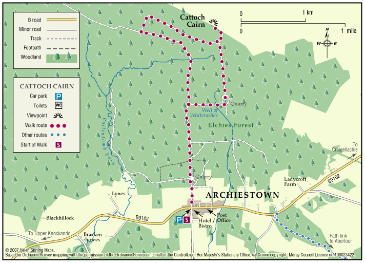
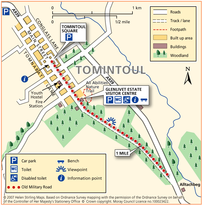
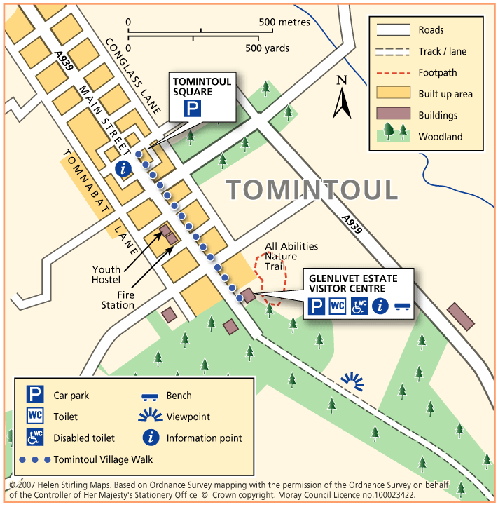
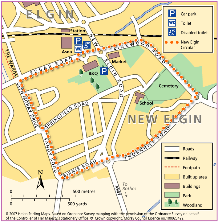
Ben Aigan and Knockmore

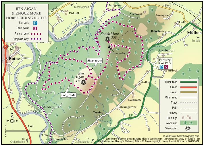
This ride takes you to the transmitter on Knockmore, the summit of Ben Aigan and stunning views of Speyside. The route described is not way-marked by the Forestry Commission as a horse-riding trail.

  • Terrain: Varied surfaces

    Mostly forest roads, some open moorland and one steep grassy track. The climb to the summit is very stony.

  • Mixed gradient

Keith – Denwell / Braehead Circuit

The route can be enjoyed in both directions, starting and finishing at the map information board in Keith Square (Reidhaven Square). As parts of the route cross open countryside and have a variety of path surfaces, stout footwear and waterproof clothing are recommended.

  • Accessibility: Suitable for a wide range of users

    The minor road sections are suitable for people of a wide range of abilities.

  • Terrain: Varied surfaces

    A combination of rough grass paths and sections of minor tarred road.

  • Gradient: Generally level

    A few gentle gradients on the Brandy Brae path.

  • No barriers
  • Fully signed

Fochabers – The Belt Path

This walk starts in Fochabers Square and travels to the Winding Walks and back again.

  • Unsuitable for wheelchairs and buggies
  • Terrain: Varied surfaces

    Pavements and compacted earth path - sections can be muddy when wet.

  • Generally level
  • Barriers: Some barriers

    Some steps

Fochabers – Fochabers Burn

This walk follows the Burn from one end of Fochabers to the other and back again. The track can be muddy in places if there has been a lot of rain. There are benches at the start and also beside the bridge at West Street.

  • Accessibility: Unsuitable for wheelchairs and buggies

    Unsuitable for Wheelchairs and buggies, but can go as far as the viewing platform at the Famous Fochaberian Garden.

  • Terrain: Gravel path

    Gravel and earth paths, so can be muddy when wet. Can also be long grass and overhanging vegetation at the side of the path.

  • Generally level
  • No barriers

Archiestown – Cairn Cattoch

Cairn Cattoch Walk is one of several waymarked walks within the forest to the north of Archiestown.

  • Accessibility: Suitable for a wide range of users

    The route is suitable for a wide range of users, although cyclists may require to dismount on the short section to the viewpoint

  • Terrain: Forest tracks

    Mainly on forest track. There is a short section of rough earth path through heather to reach the summit viewpoint. Stout footwear is advised

  • Gradient: Mixed gradient

    Long gentle climb along most of route, with a steeper section leading to the viewpoint. A total climb of 130 metres (390ft) with the summit sitting at 369 metres (1120ft) above sea level

  • No barriers
  • Fully signed

Tomintoul – Old Military Road

This linear walk follows the old military road out of Tomintoul heading to Alltachbeg. The track is undulating and wide but rutted and muddy in parts, needing sturdy footwear or wellies depending on how wet it is. The views are tremendous though, and worth the effort to see the hills and open heather moorland stretching out before you.

  • Unsuitable for wheelchairs and buggies
  • Terrain: Uneven terrain

    Gravel track - pot holed and can be muddy in wet weather.

  • Undulating
  • No barriers

Tomintoul – Village Walk

This is a linear walk which includes the all abilities route at Glenlivet Estate Office and Visitor Centre. The Visitor Centre has toilets and there are seats and benches throughout the walk.

  • Accessible for all users
  • Paved footpaths & roads
  • Generally level

Archiestown – Village Walk

This circular walk round Archiestown includes some dirt tracks and fairly exposed sections which make it unsuitable for wheelchairs and buggies. It gives outstanding views of the surrounding countryside but some parts will be very muddy in wet weather and there are sections with no pavements, so care is needed along the roads.

  • Unsuitable for wheelchairs and buggies
  • Terrain: Varied surfaces

    Mixture of Tarmac paths and gravel tracks. Can be muddy in wet weather. Can also be quite exposed.

  • Gradient: Undulating

    Some gentle inclines and declines.

Elgin – Sheriffmill Loop

This circular walk takes you along quiet roads, which head out to the west of Elgin past some beautiful old buildings. The route is along good paths and roads, and is suitable for wheelchairs and buggies, although some of the route (Old Mills Road and Jock Inkson’s Brae) has no pavements and care is needed when walking along the road.

  • Accessibility: Accessible for all with care

    Take care on road sections without pavements.

  • Gradient: Undulating

    Some gentle inclines / declines.

Elgin – Morriston Playing Fields

This circular walk follows the path round Morriston Playing Field, by the banks of the River Lossie. The path is flat but needs some care. It is suitable for most buggies but not wheelchairs.

  • Accessibility: Suitable for buggies but not wheelchairs

    Suitable for most buggies but may be be difficult during wet periods. Wheelchairs may struggle due to some uneven surfaces.

  • Terrain: Varied surfaces

    Gravel footpaths. Can be muddy/ slippy in wet weather, and liable to flooding. Also watch out for fallen leaves during the winter.

  • Generally level
  • No barriers

Elgin – The Wards

This circular walk follows a path round an area of unspoilt nature, with trees, ponds and wildlife in abundance. The path is good and suitable for wheelchairs and buggies in all weathers.

  • Accessible for all users
  • Terrain: Gravel path

    Some gravel paths and pavements.

  • Generally level
  • No barriers
  • Partly signed

Elgin – Lunchtime Walk

This is a circular walk through Elgin, starting at the bus station. It routes south past the shops on Batchen Street and then into the residential area beyond, with its old stone built terraces and villas. There are plenty of views out to the countryside and hills to the south of Elgin.

  • Accessible for all users
  • Paved footpaths & roads
  • Gradient: Undulating

    There are some long slow inclines/ declines, particularly along Batchen Street and Moss Street.

  • No barriers

Elgin – New Elgin Circular

This is a circular walk, which starts in Edgar Road and loops round south Elgin. It is all on good pavements and is suitable for wheelchairs and buggies.

  • Accessible for all users
  • Paved footpaths & roads
  • Gradient: Generally level

    Mainly level with some steady inclines and declines.

Elgin – Seafield Circular Walk

This circular walk follows part of the National Cyclepath into Cooper Park. The surfaces are good and suitable for wheelchairs and buggies, although there is an incline on Waterside Street. There are toilets and refreshments in the Library, on the other side of the Park.

  • Accessible for all users
  • Paved footpaths & roads
  • Generally level
  • No barriers

Elgin – Lesmurdie Loop

This is a short circular, well – lit walk on flat pavements, suitable for wheelchairs and buggies.

  • Accessible for all users
  • Paved footpaths & roads
  • Generally level
  • No barriers
  • Fully signed

Elgin – River Lossie Walk

This is a flat linear walk along the banks of the River Lossie. The paths are good and suitable for buggies. This is a pleasant riverside walk, along part of the specially constructed cyclepath. There is a cafΓ© and also toilets in the Library and Leisure Centre. You can extend this walk by including the Cooper Park Walk.

  • Accessible for all users
  • Paved footpaths & roads
  • Generally level
  • No barriers
  • Unsigned

Lossiemouth – Golf Course Walk

This walk takes you across the golf course to the beach look out and back. Buggies and wheelchairs can use the track with care. It has views of the Covesea Lighthouse and over the Moray Firth. It can be a little exposed if the wind is strong. Watch out for jets from RAF Lossiemouth overhead and keen golfers on the course!

  • Accessible for all with care
  • Varied surfaces
  • Generally level
  • No barriers

Buckie – Mill of Buckie Circular

This circular walk is along country lanes, tracks and paved streets and is not suitable for wheelchairs or buggies. Parts of the route can be muddy in wet weather.

  • Unsuitable for wheelchairs and buggies
  • Terrain: Varied surfaces

    Tarmac pavements and farm track which can be muddy.

  • Generally level
  • Barriers: Some barriers

    Narrow bridge with steps at Mains of Buckie.

  • Partly signed

Buckie – Portessie Circular

This circular route starts in east Buckie and includes great coastal views over the Moray Firth. Because the route is very near to the shore for part of the way, it is very exposed to cold, strong winds from the sea. There are benches along the way. The surfaces are good and the only hill is on Station Road, which is fairly steep.

  • Accessible for all with care
  • Terrain: Paved footpaths & roads

    No pavement on Station Road.

  • Gradient: Short steep sections

    Steep slope at Station Road.

  • Barriers: Some barriers

    No drop kerbs on Rathburn Street.

  • Partly signed