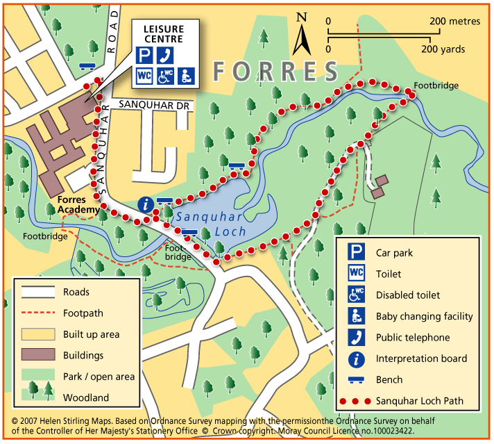
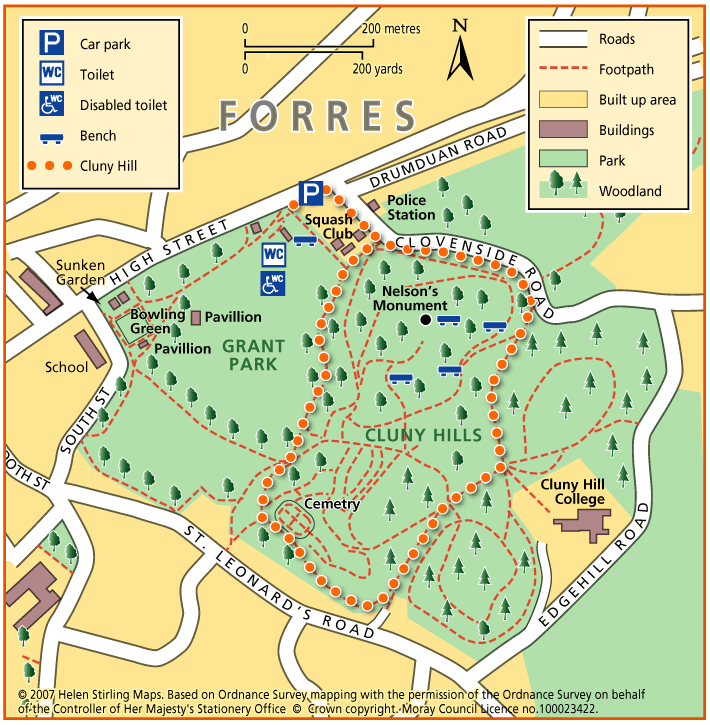
Elgin – Pinefield Park

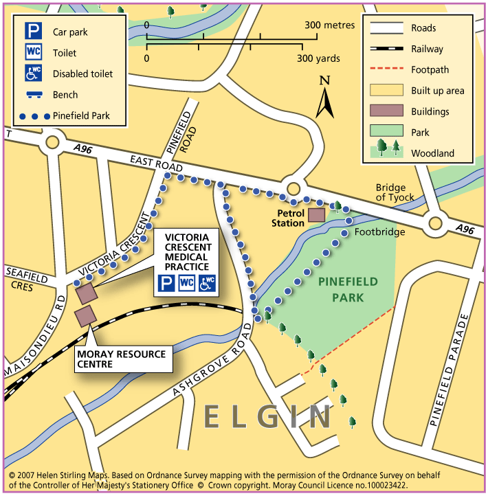
This is a circular walk, which includes the path through Pinefield Park. The route is all on good pavements and paths and is suitable for wheelchairs and buggies.

  • Accessible for all users
  • Paved footpaths & roads
  • Generally level
  • No barriers

Knock Hill & Little Knockbog

The starting point suggested is very overgrown and there is now “no right of way signs” placed. This is not a core path. There is potentially another route up via Swiebog. The car park is now closed for public use. If you have more information on this route or you would like to help maintain …

  • Unsuitable for wheelchairs and buggies
  • Slopes throughout
  • Barriers: Some barriers

    Very overgrown

  • Partly signed

The Gownie

A circular walk via Craigellachie and Aberlour for the more enthusiastic walker looking for some adventure. Initially follow Balvenie Street to the Railway Station. Walk along the platform to the left and cross the road into the car park to join the β€œSpur” to the Speyside Way.

  • Accessibility: Suitable for a wide range of users

    A route for the more energetic walker and cyclist.

  • Terrain: Varied surfaces

    Mostly surfaced access tracks particularly in lowland section with some grassy paths through fields. Rough in places

  • Gradient: Slopes throughout

    Considerable gradients to the summit of the Gownie Path at a height of around 1000ft.

  • Barriers: Some barriers

    There are some stiles and gates to be negotiated.

Logie – Sluie path

The path is a circular route through woodland, and the sections which follow the river Findhorn are very close to the cliff edge. The path is approximately three miles south of Forres.

  • Accessibility: Suitable for a wide range of users

    The route is suitable for a wide range of users but the terrain might prove difficult for the less able

  • Terrain: Forest tracks

    Mostly a woodland earth path with narrow aggregate sections, and rough vehicle tracks.

  • Gradient: Undulating

    Be aware the path is undulating and is close to steep cliffs at parts,

  • Barriers: Some barriers

    Many protruding tree roots crossing the path

  • Partly signed

Ben Aigan

Ben Aigan lies to the east of Rothes, the north east of Craigellachie and to the east of the River Spey which flows along the foot of its western and northern slopes. Rising to a height of 471m (1546 feet) and extensively forested apart from the summit cone, the top of Ben Aigan provides magnificent views over Speyside, south to Ben Rinnes, and away to the north over the Moray Firth to the hills of Sutherland

  • Unsuitable for wheelchairs and buggies
  • Defined hill path
  • Slopes throughout
  • Partly signed

Dufftown – Dufftown Dramble

‘Rome was built on seven hills, Dufftown was built on seven stills’ – so goes the old rhyme. This walk, starting from the Dufftown clock-tower, links all the Dufftown distilleries in one walk.

  • Accessibility: Suitable for a wide range of users

    Able-bodied walkers, some sections can be cycled. The nature of the terrain and the presence of physical barriers would make the route difficult to negotiate on horseback.

  • Terrain: Varied surfaces

    A mixture of tarmac, gravel and grass paths with some sections on public roads - look out for traffic. Short gradients and sections of uneven path.

  • Gradient: Undulating

    Generally level with short gradients.

  • Barriers: Some barriers

    A number of gates and steps.

  • Unsigned

Dufftown – Gordon’s Cross

The Gordons Cross Path explores the countryside around Dufftown and gives good access to all the natural attributes the area has to offer throughout the four seasons.

  • Accessibility: Suitable for a wide range of users

    The section of route between Hardhaugh and the Crachie Road Bridge is not recommended for horses or cyclists due to the nature of the route surface and the presence of physical barriers.

  • Terrain: Varied surfaces

    Fully surfaced roadside paths in the build up areas. Rough grassy and gravel paths in country sections.

  • Gradient: Short steep sections

    A total climb of 250 feet involved in traversing this route. Gentle inclines throughout but there are a few short steep sections.

  • Barriers: Some barriers

    Several gates require to be negotiated near Gordon’s Cross and beside the River Fiddich where there are also wooden steps.

  • Fully signed

Dufftown – Glenrinnes Way

A circular walk which will take you round some of the sights of Dufftown.

  • Accessible for all users
  • Terrain: Paved footpaths & roads

    A good generally level circular route with a steady climb no matter which way round you decide to walk it

  • Gradient: Generally level

    There is a steady slope to the Tomintoul Road but the ground is good.

  • No barriers
  • Fully signed

Buckie – Gollachy Circular

This route explores the coast west of Buckie as far as the village of Portgordon, returning at a higher level with extensive views over the Moray Firth.

  • Accessible for all users
  • Terrain: Varied surfaces

    Tarred pavements and gravel paths. A short section of earth path at Gollachy Burn can be muddy.

  • Gradient: Short steep sections

    Short steep section climbing up to the golf course near the Gollachy Burn

  • Fully signed

Dufftown – Balvenie Castle

This circular walk has some steep inclines and is not suitable for wheelchairs or buggies because of the terrain. It includes some woodland and has good views of the ruined castle.

  • Unsuitable for wheelchairs and buggies
  • Terrain: Varied surfaces

    Tarmac pavements, compacted earth and gravel tracks. Note that the earth track in the wood is quite narrow and can be muddy/ slippy in wet weather. Watch out for tree roots.

  • Gradient: Short steep sections

    Some steep inclines / declines, with the steepest on a ramped path section within the woodland.

  • Barriers: Some barriers

    Long flight of steps in wood.

  • Partly signed

Archiestown Woods

This is a circular route of about twelve miles through forestry and on quiet public roads. It connects with the Speyside Way and the Drum Wood circular route. The Mannoch Road is an ancient right of way that runs from Elgin to Knockando; the name comes from the Gaelic work for monk.

    Drum Wood

    This is a nice easy circular route that takes in a few miles of the Speyside Way and returns through forestry on the other side of the river. Good views to the north from the Drum Wood and very scenic alongside the Spey. This route is not waymarked and part of it runs through private land.

    • 10 miles (16 km)
    • 120 meters (393 ft)
    • Varied surfaces

    Lossie Forest & Beach

    This ride takes you through the forest from Kingston towards Lossiemouth and back either through the forest or along the edge of the beach.

    • Terrain: Coastal tracks

      Good firm sand on the beach and reasonably soft forest tracks.Β 

    • Generally level
    • No barriers

    Roseisle Beach

    A very pleasant, long beach ride. Roseisle Beach stretches for nearly eight miles from Findhorn in the west to Burghead in the east. The route described is not way-marked or maintained by the Commission as a horse-riding route.

    • Terrain: Coastal tracks

      Once across the softer sand and gravelly patches the beach sand is good and level and firm although keep an eye out for soft spots/hidden rocks/small 'streams' of water.

    • Generally level
    • No barriers
    • Partly signed

    Forres – Sanquhar Loch Path

    This is a circular route around Sanquhar Loch on paths, which can be muddy depending on the weather. Tree roots can be a problem and care needs to be taken at points along the path. This is a very scenic walk at any time of year, well signposted all the way round, with interesting wildlife particularly ducks, coots and swans.

    • Unsuitable for wheelchairs and buggies
    • Terrain: Varied surfaces

      Mainly gravel paths - can be muddy.

    • Generally level
    • Barriers: Some barriers

      Steps at the footbridge. Tree roots along some section of path.

    Forres – Cluny Hill Path

    This is a circular route on good paths with 1 steep road section at the start but then relatively flat. The walk is under a tree canopy most of the time. In autumn and winter the fallen leaves can be knee high! You can extend the walk by joining other paths round the hill.

    • Suitable for buggies but not wheelchairs
    • Terrain: Paved footpaths & roads

      Tarmac and gravel paths - can be muddy.

    • Gradient: Generally level

      One steep road section, then generally level.

    Forres – Grant Park

    This is a pleasant circular route through parkland, on good paths around the park. There are places to rest in the park. In spring and summer the flowerbeds are very picturesque. In autumn the trees are spectacular but beware of fallen leaves on the paths, which can make them very slippy if wet. You can extend this walk by joining onto Cluny Hill paths.

    • Accessible for all users
    • Paved footpaths & roads
    • Generally level

    Forres – Mosset Burn

    This is a very pleasant walk with trees, flowerbeds and birds. The paths are all good although if it has been very wet they may be a little muddy in places. There are places to sit and rest throughout the walk. You’ll need to take care crossing over Bridge Street.

    • Accessible for all users
    • Terrain: Paved footpaths & roads

      Gravel footpaths can be muddy.

    • Gradient: Generally level

      Mainly level but some downward slopes through park.