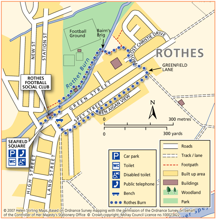
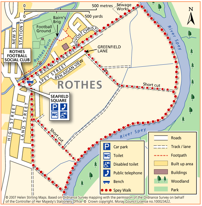
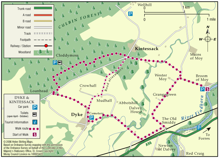
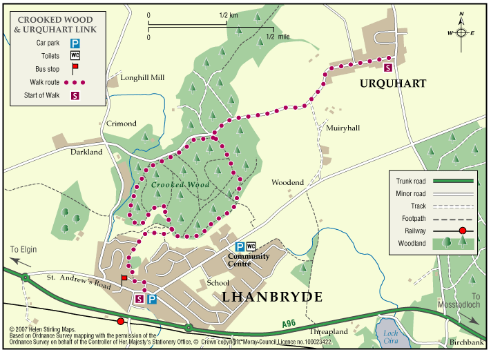
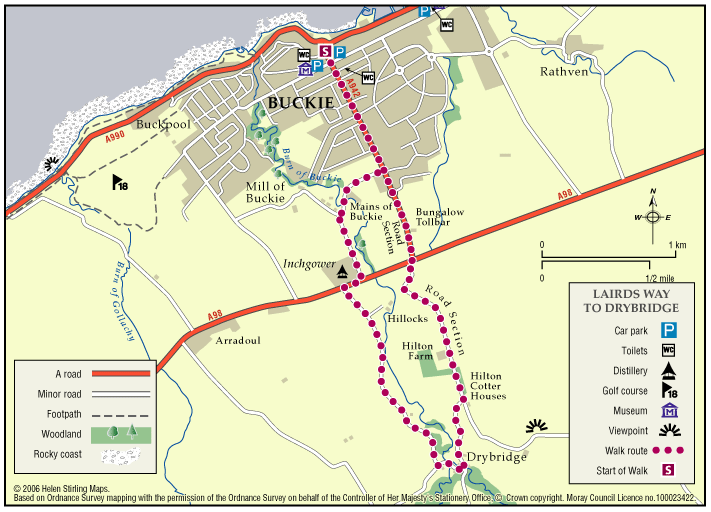
Forres – Roysvale Park

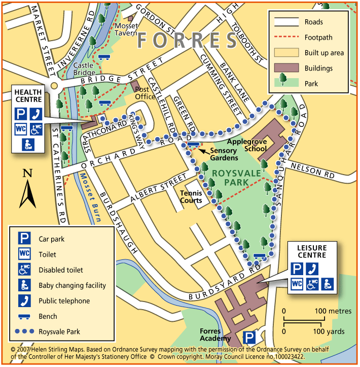
This is a flat circular route, all on pavements so suitable for wheelchairs and buggies. The Sensory Garden in Orchard Road is worth a short stop to smell the aromatic plants. There is a bench there and also one in front of the Leisure Centre. You can extend this walk to include Sanquhar Loch.

  • Accessible for all users
  • Paved footpaths & roads
  • Generally level
  • No barriers

Loch Romach and Altyre Estate

Views across the Cromarty Firth are magnificent from the High Drive on Altyre Estate. Some of this route follows the Dava Way which is way-marked but much is on private land.

    Cullen – Salmon Bothy Circular

    The Salmon Bothy Circular Path provides a short coastal walk, which takes in magnificent coastal views.

    • 1.6 miles (2.56 km)
    • 40 meters (131 ft)
    • 45 minutes
    • Accessibility: Unsuitable for wheelchairs and buggies

      There is a steep ramped path with handrail leading from the harbour area up to cliff top. Flat gravel path between the caravan park and the Nelson’s Seat viewpoint providing opportunity for less able bodied users.

    • Terrain: Varied surfaces

      Fully surfaced roadside paths in the built up areas. Bound gravel paths elsewhere, with a short steep section of rough grassy path at the outlying gully. There are plans for this section to be upgraded to gravel.

    • Gradient: Mixed gradient

      Relatively flat throughout but there are two short steep sections.

    • Barriers: Some barriers

      There is a steep ramped path with handrail leading from the harbour area up to cliff top.

    • Fully signed

    Hopeman – Beach and Lodge Walk

    This is an extension of the Level 1 Beach Walk, following the coast path past the beach huts and turning inland up Lodge Lane.

    • Unsuitable for wheelchairs and buggies
    • Terrain: Varied surfaces

      Mainly tarmac pavements and paths, but gravel section at Lodge Lane. Care to be taken on Lodge Lane, which can be muddy in wet weather.

    • Gradient: Short steep sections

      Steady incline up lodge lane. Relatively level elsewhere.

    Hopeman – Railway Path

    This walk takes you from Hopeman Surgery on a circular route along part of the old railway line to Cummingston. It is quite sheltered along the old track and has lovely views over the Moray Firth with potential to spot dolphins. The section from Cummingston back towards Hopeman is along a pavement next to a relatively busy road so care will be required.

    • Unsuitable for wheelchairs and buggies
    • Terrain: Varied surfaces

      Gravel paths and tarmac pavements.

    • Gradient: Generally level

      Relatively level, with short downwards slope to the old railway line in Hopeman and short steep incline to the bridge near Cummingston.

    • Barriers: Some barriers

      Steps down to railway path at the Hopeman end.

    • Partly signed

    Aberlour – Alice Littler Park

    This circular walk round Alice Littler Park is flat and on good paths, making it suitable for wheelchairs and buggies. The path follows the course of the River Spey as it speeds through Aberlour, under the amazing Victoria Bridge. The park itself is full of flower beds and shrubs making this a lovely walk throughout the year. The Speyside Way Visitor Centre is open from March to October and is worth a look in to discover the history and wildlife of the area.

    • Accessible for all users
    • Paved footpaths & roads
    • Generally level
    • Unsigned

    Craigellachie – Telford Bridge

    This is a linear walk along level paths, which include grass tracks and so is not suitable for wheelchairs and buggies. It follows part of the Speyside Way and has beautiful riverside views to the famous Thomas Telford metal bridge. There are benches in the car parks at both ends of the walk and seasonal toilets in Fiddich Park.

    • Unsuitable for wheelchairs and buggies
    • Terrain: Varied surfaces

      Compacted earth and gravel paths with some grass sections. Timber bridge. The path also passes under the road bridge.

    • Generally level
    • Partly signed

    Craigellachie – Dufftown Spur

    This is a beautiful, flat, tree – lined sheltered walk along a good path. It is suitable for wheelchairs and buggies with care, although it can be a little muddy in places.

    • Accessibility: Accessible for all with care

      Can be muddy.

    • Terrain: Varied surfaces

      Flat gravel and compacted earth path - can be a little muddy.

    • Generally level
    • Barriers: Some barriers

      Potential Landslides further along path.

    • Unsigned

    Dufftown – Town Walk

    Dufftown is built on a hill and surrounded by hills, giving great views of the countryside but challenging to walkers. The Town Walk includes some inclines, but is all on good pavements and is suitable for wheelchairs and buggies.

    • Accessible for all users
    • Paved footpaths & roads
    • Undulating
    • Fully signed

    Rothes – Burn Walk

    This flat, circular walk follows the Rothes Burn as it passes through the Playing Fields and also includes some great views over the open countryside to Ben Aigen. The surfaces are all good and are suitable for wheelchairs and buggies, although care is needed over the footbridges.

    • Accessible for all users
    • Paved footpaths & roads
    • Generally level
    • Barriers: No barriers

      Take care crossing the footbridges.

    Rothes – Spey Walk

    This flat, circular walk follows the River Spey on it’s way from Craigellachie to Boat o’ Brig. The path is good but is not suitable for wheelchairs or buggies. The scenery along this walk is very beautiful at any time of year, although it can be a little exposed in places and the paths can be muddy in wet weather.

    • Unsuitable for wheelchairs and buggies
    • Terrain: Varied surfaces

      Mainly grass and earth path, with some sections of farm track and tarmac. Paths can be muddy when wet.

    • Generally level

    Forres – Dyke & Kintessack Circular

    A circular route linking the rural communities of Dyke and Kintessack, with a spur to Broom of Moy, and on to the wider network of paths around Forres.

    • Unsuitable for wheelchairs and buggies
    • Terrain: Varied surfaces

      Minor tarmac roads, forest tracks, earth paths, and short sections of gravel paths. NOTE: In the winter a short section of the path between Dyke and Culbin Forest (at Loanhead) can be very wet. Waterproof boots or wellingtons are advised.

    • Generally level
    • Barriers: Some barriers

      Bridge with steps located at Wellhead.

    • Fully signed

    Lhanbryde – Crooked Wood and Urquhart

    Located just a few miles east of Elgin, the woodland and countryside around the village of Lhanbryde provide a great opportunity for outdoor access.

    • Unsuitable for wheelchairs and buggies
    • Terrain: Varied surfaces

      Informal earth path within the woodland, with several short steep sections. Generally dry but can be muddy in places, so stout footwear is recommended. There is a quiet section of public road between Crooked Wood and Urquhart.

    • Gradient: Short steep sections

      Although generally level or gently undulating, there are some short steep sections, particularly within the woodland.

    • Barriers: Some barriers

      A flight of steps near the entrance to the wood. Two short steep sections of path within the woodland are slippy when wet. Also watch out for tree roots.

    • Fully signed

    Buckie – Laird’s Way to Drybridge

    The peaceful village of Drybridge sits above Buckie surrrounded by woods and farmland. Follow the way from Buckie over the Buckie Burn and past the distillery. On the way to Drybridge you will be rewarded with fine views over farmland and beyond to the Firth.

    • Fully signed

    Buckie – Strathlene all abilities path

    Located near Buckie, this is a short section of coastal all abilities path, which runs parallel to the rocky foreshore near the old Strathlene lido. There are views to the nearby Craigen Roan rock where seals can be regularly seen and heard. This path forms part of the Moray Coast Trail – Buckie.

    • Accessible for all users
    • Gravel path
    • Generally level
    • Fully signed

    Keith – The Green Roadies

    Enjoy the many different species of flowers, shrubs and birds that can be identified. Marvel at the fine views of all the surrounding hills that can be seen across green fields and farmland.

    • Unsuitable for wheelchairs and buggies
    • Terrain: Varied surfaces

      A combination of tarred roadside paths, minor roads, aggregate paths and rough grassy tracks. The grassy track sections, although flat, are muddy in places and can be difficult to negotiate.

    • Gradient: Generally level

      A few gentle gradients in places.

    • Barriers: Some barriers

      Several gates at the cemetery.

    • Fully signed

    Keith – Braehead and Cottage Wood

    This nature walk has an abundance of flowers, shrubs, trees and wildlife along the river and hedges set against a background of heather and tree clad hills.

    • Suitable for a wide range of users
    • Terrain: Varied surfaces

      A combination of tarred minor roads, aggregate paths and grassy tracks.

    • Undulating
    • Barriers: Some barriers

      Steps in two places (The Cottage Wood and the Auld Brig)

    • Fully signed

    The Isla Way

    This 13 mile route has a great variety in scenery and setting, and you will always be rewarded with natural beauty wherever you are on the path. The route follows the valley of the infant River Isla, which rises in the hills above Drummuir on its way to Keith and the Moray Coast beyond.

    • Accessibility: Unsuitable for wheelchairs and buggies

      All of the route can be used for walking, cycling, and horseriding.

    • Terrain: Varied surfaces

      Surfaces are generally sound including tar, gravel and earth paths. In places the trail follows narrow tarmac public roads, and road pavements through Dufftown and Keith. Sections of the paths will be muddy when wet.

    • Gradient: Undulating

      The route climbs to around 300 metres (1,000ft) above sea level. Total height climbed is modest at around 240 metres (780 ft). Slopes are generally easy, although there are a couple of steep sections to be negotiated.

    • Barriers: Many barriers

      Between Dufftown and Loch Park there is a narrow suspension bridge across the River Fiddoch. There are some steps in the Toon Widd at Dufftown.Loch Park to Drummuir has no barriers and is an all abilities standard.Between Drummuir and Keith there are unsigned sections on public roads, including a mile section on busy B9014, where users are next to fast traffic.Two field gates exist across the path above Auchindachy.

    • Partly signed

    The Dava Way

    The Dava Way is a 23 mile trail across the ancient Celtic province of Morayshire between the historic towns of Forres and Grantown-on-Spey. The route links Strathspey and the Cairngorms National Park with the Moray Coast in North East Scotland. Almost all of the route follows the old Highland Railway line and is off road and safe from traffic.

    • Accessibility: Suitable for a wide range of users

      WALKING - The surface is varied, mostly firm and good, but it can be wet and rough in places. All of it is fine for walking. CYCLING - The Dava Way can be used as an ‘off road’ cycling route, as most of it is over a firm but rough surface.

    • Terrain: Varied surfaces

      The surface of the path is generally compacted track-bed material, rough and rutted in places, and is good for walking and 'off-road’ cycling. Depending on the weather, stretches may be wet but the Dava Way Volunteers have installed new drains and this has improved the paths.

    • Gradient: Gentle gradients

      The route has a very gradual gradient which rises on the Dava Moor to 320m (1050ft) above sea level at its highest point.

    • Barriers: Some barriers

      The are a number of opening gates as you approach Grantown. There are low steps at the track end at Grantown.

    • Fully signed

    Moray Coastal Cycle Route

    This is a signed cycle route from Burghead to Cullen, linking the coastal communities. Explore the dramatic landscapes from rugged cliffs to sweeping shores, sheltered coves to fishertown harbours. Visitors are drawn by the resident bottlenose dolphins and the myriad of birdlife on the cliffs.

    • Accessibility: Suitable for a wide range of users

      Suitable for all types of bikes. Some sections are suitable for walking and horse riding.

    • Terrain: Paved footpaths & roads

      Good surfacing through out, combining a mixture of gravel paths, tarmac paths, and public road sections.

    • Generally level
    • Barriers: Some barriers

      Some road crossings.

    • Fully signed