Keith – The Green Roadies

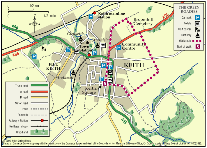
Enjoy the many different species of flowers, shrubs and birds that can be identified. Marvel at the fine views of all the surrounding hills that can be seen across green fields and farmland.

  • Unsuitable for wheelchairs and buggies
  • Terrain: Varied surfaces

    A combination of tarred roadside paths, minor roads, aggregate paths and rough grassy tracks. The grassy track sections, although flat, are muddy in places and can be difficult to negotiate.

  • Gradient: Generally level

    A few gentle gradients in places.

  • Barriers: Some barriers

    Several gates at the cemetery.

  • Fully signed

Buckie – Strathlene all abilities path

Located near Buckie, this is a short section of coastal all abilities path, which runs parallel to the rocky foreshore near the old Strathlene lido. There are views to the nearby Craigen Roan rock where seals can be regularly seen and heard. This path forms part of the Moray Coast Trail – Buckie.

  • Accessible for all users
  • Gravel path
  • Generally level
  • Fully signed

Buckie – Laird’s Way to Drybridge

The peaceful village of Drybridge sits above Buckie surrrounded by woods and farmland. Follow the way from Buckie over the Buckie Burn and past the distillery. On the way to Drybridge you will be rewarded with fine views over farmland and beyond to the Firth.

  • Fully signed

Lhanbryde – Crooked Wood and Urquhart

Located just a few miles east of Elgin, the woodland and countryside around the village of Lhanbryde provide a great opportunity for outdoor access.

  • Unsuitable for wheelchairs and buggies
  • Terrain: Varied surfaces

    Informal earth path within the woodland, with several short steep sections. Generally dry but can be muddy in places, so stout footwear is recommended. There is a quiet section of public road between Crooked Wood and Urquhart.

  • Gradient: Short steep sections

    Although generally level or gently undulating, there are some short steep sections, particularly within the woodland.

  • Barriers: Some barriers

    A flight of steps near the entrance to the wood. Two short steep sections of path within the woodland are slippy when wet. Also watch out for tree roots.

  • Fully signed

Forres – Dyke & Kintessack Circular

A circular route linking the rural communities of Dyke and Kintessack, with a spur to Broom of Moy, and on to the wider network of paths around Forres.

  • Unsuitable for wheelchairs and buggies
  • Terrain: Varied surfaces

    Minor tarmac roads, forest tracks, earth paths, and short sections of gravel paths. NOTE: In the winter a short section of the path between Dyke and Culbin Forest (at Loanhead) can be very wet. Waterproof boots or wellingtons are advised.

  • Generally level
  • Barriers: Some barriers

    Bridge with steps located at Wellhead.

  • Fully signed

Rothes – Spey Walk

This flat, circular walk follows the River Spey on it’s way from Craigellachie to Boat o’ Brig. The path is good but is not suitable for wheelchairs or buggies. The scenery along this walk is very beautiful at any time of year, although it can be a little exposed in places and the paths can be muddy in wet weather.

  • Unsuitable for wheelchairs and buggies
  • Terrain: Varied surfaces

    Mainly grass and earth path, with some sections of farm track and tarmac. Paths can be muddy when wet.

  • Generally level
  • Unsigned

Rothes – Burn Walk

This flat, circular walk follows the Rothes Burn as it passes through the Playing Fields and also includes some great views over the open countryside to Ben Aigen. The surfaces are all good and are suitable for wheelchairs and buggies, although care is needed over the footbridges.

  • Accessible for all users
  • Paved footpaths & roads
  • Generally level
  • Barriers: No barriers

    Take care crossing the footbridges.

  • Unsigned

Dufftown – Town Walk

Dufftown is built on a hill and surrounded by hills, giving great views of the countryside but challenging to walkers. The Town Walk includes some inclines, but is all on good pavements and is suitable for wheelchairs and buggies.

  • Accessible for all users
  • Paved footpaths & roads
  • Undulating
  • Fully signed

Craigellachie – Dufftown Spur

This is a beautiful, flat, tree – lined sheltered walk along a good path. It is suitable for wheelchairs and buggies with care, although it can be a little muddy in places.

  • Accessibility: Accessible for all with care

    Can be muddy.

  • Terrain: Varied surfaces

    Flat gravel and compacted earth path - can be a little muddy.

  • Generally level
  • Barriers: Some barriers

    Potential Landslides further along path.

  • Unsigned

Craigellachie – Telford Bridge

This is a linear walk along level paths, which include grass tracks and so is not suitable for wheelchairs and buggies. It follows part of the Speyside Way and has beautiful riverside views to the famous Thomas Telford metal bridge. There are benches in the car parks at both ends of the walk and seasonal toilets in Fiddich Park.

  • Unsuitable for wheelchairs and buggies
  • Terrain: Varied surfaces

    Compacted earth and gravel paths with some grass sections. Timber bridge. The path also passes under the road bridge.

  • Generally level
  • Partly signed

Aberlour – Alice Littler Park

This circular walk round Alice Littler Park is flat and on good paths, making it suitable for wheelchairs and buggies. The path follows the course of the River Spey as it speeds through Aberlour, under the amazing Victoria Bridge. The park itself is full of flower beds and shrubs making this a lovely walk throughout the year. The Speyside Way Visitor Centre is open from March to October and is worth a look in to discover the history and wildlife of the area.

  • Accessible for all users
  • Paved footpaths & roads
  • Generally level
  • Unsigned

Hopeman – Railway Path

This walk takes you from Hopeman Surgery on a circular route along part of the old railway line to Cummingston. It is quite sheltered along the old track and has lovely views over the Moray Firth with potential to spot dolphins. The section from Cummingston back towards Hopeman is along a pavement next to a relatively busy road so care will be required.

  • Unsuitable for wheelchairs and buggies
  • Terrain: Varied surfaces

    Gravel paths and tarmac pavements.

  • Gradient: Generally level

    Relatively level, with short downwards slope to the old railway line in Hopeman and short steep incline to the bridge near Cummingston.

  • Barriers: Some barriers

    Steps down to railway path at the Hopeman end.

  • Partly signed

Hopeman – Beach and Lodge Walk

This is an extension of the Level 1 Beach Walk, following the coast path past the beach huts and turning inland up Lodge Lane.

  • Unsuitable for wheelchairs and buggies
  • Terrain: Varied surfaces

    Mainly tarmac pavements and paths, but gravel section at Lodge Lane. Care to be taken on Lodge Lane, which can be muddy in wet weather.

  • Gradient: Short steep sections

    Steady incline up lodge lane. Relatively level elsewhere.

Cullen – Salmon Bothy Circular

The Salmon Bothy Circular Path provides a short coastal walk, which takes in magnificent coastal views.

  • 1.6 miles (2.56 km)
  • 40 meters (131 ft)
  • 45 minutes
  • Accessibility: Unsuitable for wheelchairs and buggies

    There is a steep ramped path with handrail leading from the harbour area up to cliff top. Flat gravel path between the caravan park and the Nelson’s Seat viewpoint providing opportunity for less able bodied users.

  • Terrain: Varied surfaces

    Fully surfaced roadside paths in the built up areas. Bound gravel paths elsewhere, with a short steep section of rough grassy path at the outlying gully. There are plans for this section to be upgraded to gravel.

  • Gradient: Mixed gradient

    Relatively flat throughout but there are two short steep sections.

  • Barriers: Some barriers

    There is a steep ramped path with handrail leading from the harbour area up to cliff top.

  • Fully signed