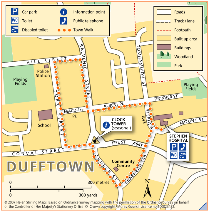
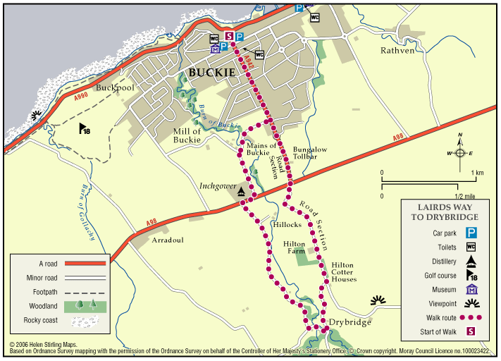
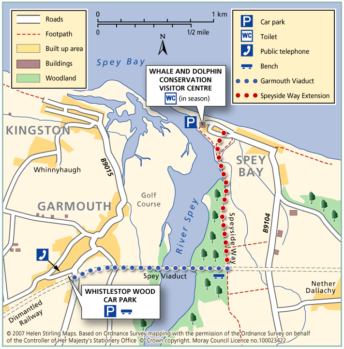
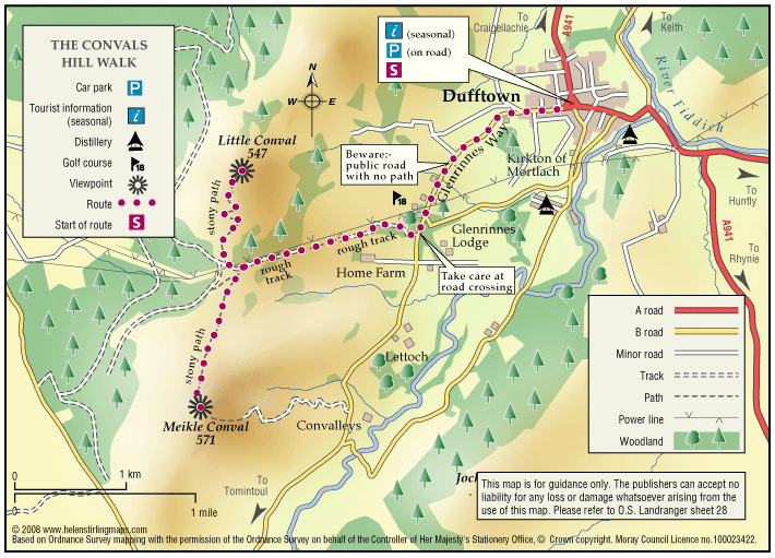
Craigellachie – Dufftown Spur

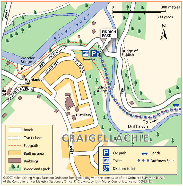
This is a beautiful, flat, tree – lined sheltered walk along a good path. It is suitable for wheelchairs and buggies with care, although it can be a little muddy in places.

  • Accessibility: Accessible for all with care

    Can be muddy.

  • Terrain: Varied surfaces

    Flat gravel and compacted earth path - can be a little muddy.

  • Generally level
  • Barriers: Some barriers

    Potential Landslides further along path.

  • Unsigned

Dufftown – Town Walk

Dufftown is built on a hill and surrounded by hills, giving great views of the countryside but challenging to walkers. The Town Walk includes some inclines, but is all on good pavements and is suitable for wheelchairs and buggies.

  • Accessible for all users
  • Paved footpaths & roads
  • Undulating
  • Fully signed

Rothes – Spey Walk

This flat, circular walk follows the River Spey on it’s way from Craigellachie to Boat o’ Brig. The path is good but is not suitable for wheelchairs or buggies. The scenery along this walk is very beautiful at any time of year, although it can be a little exposed in places and the paths can be muddy in wet weather.

  • Unsuitable for wheelchairs and buggies
  • Terrain: Varied surfaces

    Mainly grass and earth path, with some sections of farm track and tarmac. Paths can be muddy when wet.

  • Generally level

Forres – Dyke & Kintessack Circular

A circular route linking the rural communities of Dyke and Kintessack, with a spur to Broom of Moy, and on to the wider network of paths around Forres.

  • Unsuitable for wheelchairs and buggies
  • Terrain: Varied surfaces

    Minor tarmac roads, forest tracks, earth paths, and short sections of gravel paths. NOTE: In the winter a short section of the path between Dyke and Culbin Forest (at Loanhead) can be very wet. Waterproof boots or wellingtons are advised.

  • Generally level
  • Barriers: Some barriers

    Bridge with steps located at Wellhead.

  • Fully signed

Lhanbryde – Crooked Wood and Urquhart

Located just a few miles east of Elgin, the woodland and countryside around the village of Lhanbryde provide a great opportunity for outdoor access.

  • Unsuitable for wheelchairs and buggies
  • Terrain: Varied surfaces

    Informal earth path within the woodland, with several short steep sections. Generally dry but can be muddy in places, so stout footwear is recommended. There is a quiet section of public road between Crooked Wood and Urquhart.

  • Gradient: Short steep sections

    Although generally level or gently undulating, there are some short steep sections, particularly within the woodland.

  • Barriers: Some barriers

    A flight of steps near the entrance to the wood. Two short steep sections of path within the woodland are slippy when wet. Also watch out for tree roots.

  • Fully signed

Buckie – Laird’s Way to Drybridge

The peaceful village of Drybridge sits above Buckie surrrounded by woods and farmland. Follow the way from Buckie over the Buckie Burn and past the distillery. On the way to Drybridge you will be rewarded with fine views over farmland and beyond to the Firth.

  • Fully signed

Buckie – Strathlene all abilities path

Located near Buckie, this is a short section of coastal all abilities path, which runs parallel to the rocky foreshore near the old Strathlene lido. There are views to the nearby Craigen Roan rock where seals can be regularly seen and heard. This path forms part of the Moray Coast Trail – Buckie.

  • Accessible for all users
  • Gravel path
  • Generally level
  • Fully signed

The Isla Way

This 13 mile route has a great variety in scenery and setting, and you will always be rewarded with natural beauty wherever you are on the path. The route follows the valley of the infant River Isla, which rises in the hills above Drummuir on its way to Keith and the Moray Coast beyond.

  • Accessibility: Unsuitable for wheelchairs and buggies

    All of the route can be used for walking, cycling, and horseriding.

  • Terrain: Varied surfaces

    Surfaces are generally sound including tar, gravel and earth paths. In places the trail follows narrow tarmac public roads, and road pavements through Dufftown and Keith. Sections of the paths will be muddy when wet.

  • Gradient: Undulating

    The route climbs to around 300 metres (1,000ft) above sea level. Total height climbed is modest at around 240 metres (780 ft). Slopes are generally easy, although there are a couple of steep sections to be negotiated.

  • Barriers: Many barriers

    Between Dufftown and Loch Park there is a narrow suspension bridge across the River Fiddoch. There are some steps in the Toon Widd at Dufftown.Loch Park to Drummuir has no barriers and is an all abilities standard.Between Drummuir and Keith there are unsigned sections on public roads, including a mile section on busy B9014, where users are next to fast traffic.Two field gates exist across the path above Auchindachy.

  • Partly signed

The Dava Way

The Dava Way is a 23 mile trail across the ancient Celtic province of Morayshire between the historic towns of Forres and Grantown-on-Spey. The route links Strathspey and the Cairngorms National Park with the Moray Coast in North East Scotland. Almost all of the route follows the old Highland Railway line and is off road and safe from traffic.

  • Accessibility: Suitable for a wide range of users

    WALKING - The surface is varied, mostly firm and good, but it can be wet and rough in places. All of it is fine for walking. CYCLING - The Dava Way can be used as an β€˜off road’ cycling route, as most of it is over a firm but rough surface.

  • Terrain: Varied surfaces

    The surface of the path is generally compacted track-bed material, rough and rutted in places, and is good for walking and 'off-road’ cycling. Depending on the weather, stretches may be wet but the Dava Way Volunteers have installed new drains and this has improved the paths.

  • Gradient: Gentle gradients

    The route has a very gradual gradient which rises on the Dava Moor to 320m (1050ft) above sea level at its highest point.

  • Barriers: Some barriers

    The are a number of opening gates as you approach Grantown. There are low steps at the track end at Grantown.

  • Fully signed

Rothes – The Dounie

This walk follows the Rothes Burn upstream to the Giant’s Table and the Fairy Rock – volcanic outcrops worn and shaped by thousands of years of erosion – and returns by the track skirting the golf course.

  • Suitable for a wide range of users
  • Varied surfaces
  • Gradient: Mixed gradient

    Varying gradients, climbing to 250m.

  • Barriers: Some barriers

    Some steps

  • Fully signed

Garmouth – Viaduct

This walk follows the old railway track from Garmouth over the River Spey viaduct, with great views over the golf course to the sea at Kingston. It is part of the National Cycle Network and also the Speyside Way. The track is good and suitable for wheelchairs and buggies.

  • Accessibility: Accessible for all users

    The extended route Level 3 is unsuitable for wheelchairs and buggies.

  • Terrain: Paved footpaths & roads

    Tarmac and all abilities surface over viaduct. The extended level 3 route is compacted earth path and can be muddy in wet weather.

  • Generally level
  • No barriers

Dufftown – The Convals

The Convals (Meikle Conval, 571m and Little Conval, 552m) are the two ’rounded humps’ separated from Ben Rinnes by the ‘Beatshach’, the pass linking Speyside to Glen Rinnes.

    Logie – Estate Paths

    There are two dramatic river walks located on the Logie Estate within the beautiful Findhorn Valley, near the town of Forres. They start at the Logie Steading Visitor Centre, which houses the River Findhorn Heritage Centre, and has Arts and Crafts, Shopping, Walled Gardens, River Walks, an Adventure Playground and CafΓ©.

    • Unsuitable for wheelchairs and buggies
    • Terrain: Varied surfaces

      The paths are narrow and steep sided in places.

    • Fully signed

    Lossiemouth Loop

    One of five Circular Cycle Routes in Moray, the Lossiemouth Loop takes you from the West Beach Car Park in Lossiemouth, round the perimeter of the airfield via Duffus Castle and back. The whole route is relatively flat and passes through fertile farming country.

    • Paved footpaths & roads
    • Generally level
    • No barriers
    • Fully signed

    Brodie – Castle Path

    Brodie Castle has a variety of paths offering a wide choice of scenic and historic features along the routes.

    • Accessibility: Accessible for all users

      The path around the pond and the woodland paths are suitable for wheelchairs and mobility scooters.

    • Forest tracks
    • Generally level
    • Barriers: Some barriers

      There is a gated single track road crossing between the Castle and the pond walk

    Dufftown – Pitglassie Viewpoint

    Pitglassie Viewpoint is one of many walks in Dufftown, it is a circular path, but either way you have a bit of a climb.

    • Unsuitable for wheelchairs and buggies
    • Gradient: Undulating

      Steady climb from either direction

    • Unsigned

    Dufftown – Robbie Dhu

    Robbie Dhu path does have a steep climb but has beautiful views to make it worth the effort.

    • Suitable for a wide range of users
    • Short steep sections