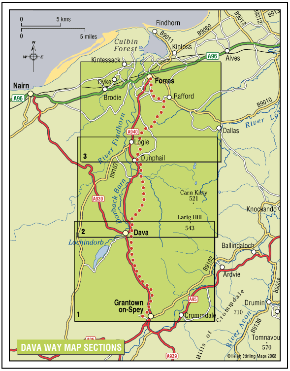
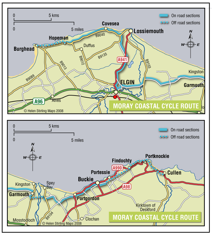
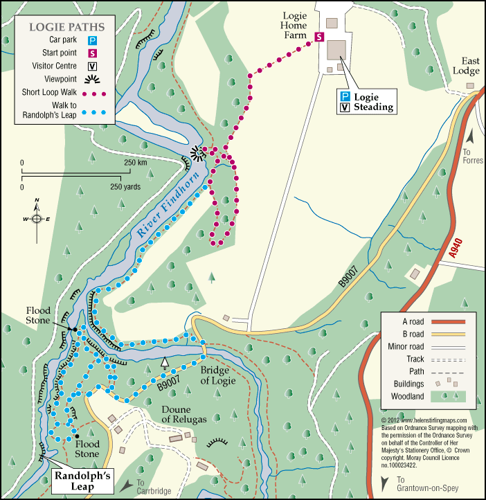
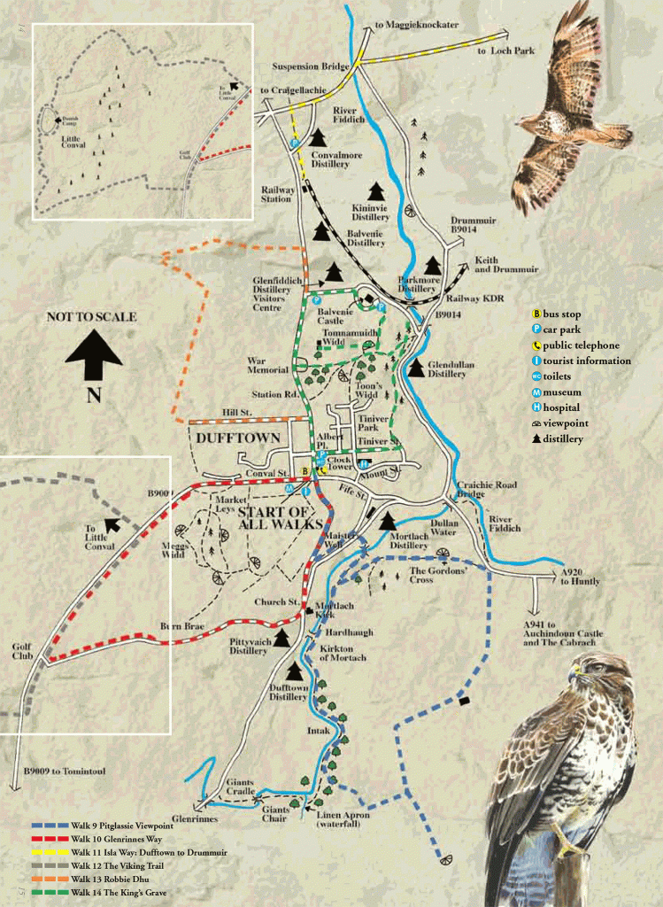
Keith – Braehead and Cottage Wood

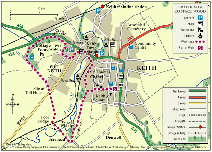
This nature walk has an abundance of flowers, shrubs, trees and wildlife along the river and hedges set against a background of heather and tree clad hills.

  • Suitable for a wide range of users
  • Terrain: Varied surfaces

    A combination of tarred minor roads, aggregate paths and grassy tracks.

  • Undulating
  • Barriers: Some barriers

    Steps in two places (The Cottage Wood and the Auld Brig)

  • Fully signed

The Dava Way

The Dava Way is a 23 mile trail across the ancient Celtic province of Morayshire between the historic towns of Forres and Grantown-on-Spey. The route links Strathspey and the Cairngorms National Park with the Moray Coast in North East Scotland. Almost all of the route follows the old Highland Railway line and is off road and safe from traffic.

  • Accessibility: Suitable for a wide range of users

    WALKING - The surface is varied, mostly firm and good, but it can be wet and rough in places. All of it is fine for walking. CYCLING - The Dava Way can be used as an β€˜off road’ cycling route, as most of it is over a firm but rough surface.

  • Terrain: Varied surfaces

    The surface of the path is generally compacted track-bed material, rough and rutted in places, and is good for walking and 'off-road’ cycling. Depending on the weather, stretches may be wet but the Dava Way Volunteers have installed new drains and this has improved the paths.

  • Gradient: Gentle gradients

    The route has a very gradual gradient which rises on the Dava Moor to 320m (1050ft) above sea level at its highest point.

  • Barriers: Some barriers

    The are a number of opening gates as you approach Grantown. There are low steps at the track end at Grantown.

  • Fully signed

Moray Coastal Cycle Route

This is a signed cycle route from Burghead to Cullen, linking the coastal communities. Explore the dramatic landscapes from rugged cliffs to sweeping shores, sheltered coves to fishertown harbours. Visitors are drawn by the resident bottlenose dolphins and the myriad of birdlife on the cliffs.

  • Accessibility: Suitable for a wide range of users

    Suitable for all types of bikes. Some sections are suitable for walking and horse riding.

  • Terrain: Paved footpaths & roads

    Good surfacing through out, combining a mixture of gravel paths, tarmac paths, and public road sections.

  • Generally level
  • Barriers: Some barriers

    Some road crossings.

  • Fully signed

Rothes – The Dounie

This walk follows the Rothes Burn upstream to the Giant’s Table and the Fairy Rock – volcanic outcrops worn and shaped by thousands of years of erosion – and returns by the track skirting the golf course.

  • Suitable for a wide range of users
  • Varied surfaces
  • Gradient: Mixed gradient

    Varying gradients, climbing to 250m.

  • Barriers: Some barriers

    Some steps

  • Fully signed

Garmouth – Viaduct

This walk follows the old railway track from Garmouth over the River Spey viaduct, with great views over the golf course to the sea at Kingston. It is part of the National Cycle Network and also the Speyside Way. The track is good and suitable for wheelchairs and buggies.

  • Accessibility: Accessible for all users

    The extended route Level 3 is unsuitable for wheelchairs and buggies.

  • Terrain: Paved footpaths & roads

    Tarmac and all abilities surface over viaduct. The extended level 3 route is compacted earth path and can be muddy in wet weather.

  • Generally level
  • No barriers

Dufftown – The Convals

The Convals (Meikle Conval, 571m and Little Conval, 552m) are the two ’rounded humps’ separated from Ben Rinnes by the ‘Beatshach’, the pass linking Speyside to Glen Rinnes.

    Logie – Estate Paths

    There are two dramatic river walks located on the Logie Estate within the beautiful Findhorn Valley, near the town of Forres. They start at the Logie Steading Visitor Centre, which houses the River Findhorn Heritage Centre, and has Arts and Crafts, Shopping, Walled Gardens, River Walks, an Adventure Playground and CafΓ©.

    • Unsuitable for wheelchairs and buggies
    • Terrain: Varied surfaces

      The paths are narrow and steep sided in places.

    • Fully signed

    Lossiemouth Loop

    One of five Circular Cycle Routes in Moray, the Lossiemouth Loop takes you from the West Beach Car Park in Lossiemouth, round the perimeter of the airfield via Duffus Castle and back. The whole route is relatively flat and passes through fertile farming country.

    • Paved footpaths & roads
    • Generally level
    • No barriers
    • Fully signed

    Brodie – Castle Path

    Brodie Castle has a variety of paths offering a wide choice of scenic and historic features along the routes.

    • Accessibility: Accessible for all users

      The path around the pond and the woodland paths are suitable for wheelchairs and mobility scooters.

    • Forest tracks
    • Generally level
    • Barriers: Some barriers

      There is a gated single track road crossing between the Castle and the pond walk

    Dufftown – Pitglassie Viewpoint

    Pitglassie Viewpoint is one of many walks in Dufftown, it is a circular path, but either way you have a bit of a climb.

    • Unsuitable for wheelchairs and buggies
    • Gradient: Undulating

      Steady climb from either direction

    • Unsigned

    Dufftown – Robbie Dhu

    Robbie Dhu path does have a steep climb but has beautiful views to make it worth the effort.

    • Suitable for a wide range of users
    • Short steep sections

    Dufftown – The Viking Trail

    The Viking Trail has two routes to follow one approximately five miles long the other being much longer at twelve miles.

    • Unsuitable for wheelchairs and buggies
    • Mixed gradient

    Forres – Engineering Past and Present

    An interesting and varied circular walk on the outskirts of Forres which visits some of the engineering projects that have changed the local landscape from the 19th century to the present day.

    • Suitable for a wide range of users
    • Terrain: Varied surfaces

      Mixture of tarmacked paths, stepped sections, woodland tracks and earth paths with some undulating sections.

    • Generally level
    • Barriers: Some barriers

      There are a few stepped sections and two wooden bridge crossings over the Burn o' Mosset.

    • Unsigned

    Forres – Califer Hill & Rafford

    A circular walk along minor roads and footpaths with stunning views from Califer Viewpoint, returning via lower Rafford and the Dava Way with a shorter route option from Rafford Church available.

    • Suitable for a wide range of users
    • Terrain: Varied surfaces

      Minor Roads, Grassy Lanes, Farm Tracks, Footpaths, Woodland Tracks, some potentially muddy and slippy parts following wet weather and some narrower sections.

    • Gradient: Generally level

      Most of this route is relatively level with the steepest section being the ascent and descent to and from Califer Hill Viewpoint.Β  The viewpoint ascends to 184.5m.

    • Barriers:

      There are footbridges to cross and some narrower sections.

    • Unsigned