Keith – Simpson Memorial Park
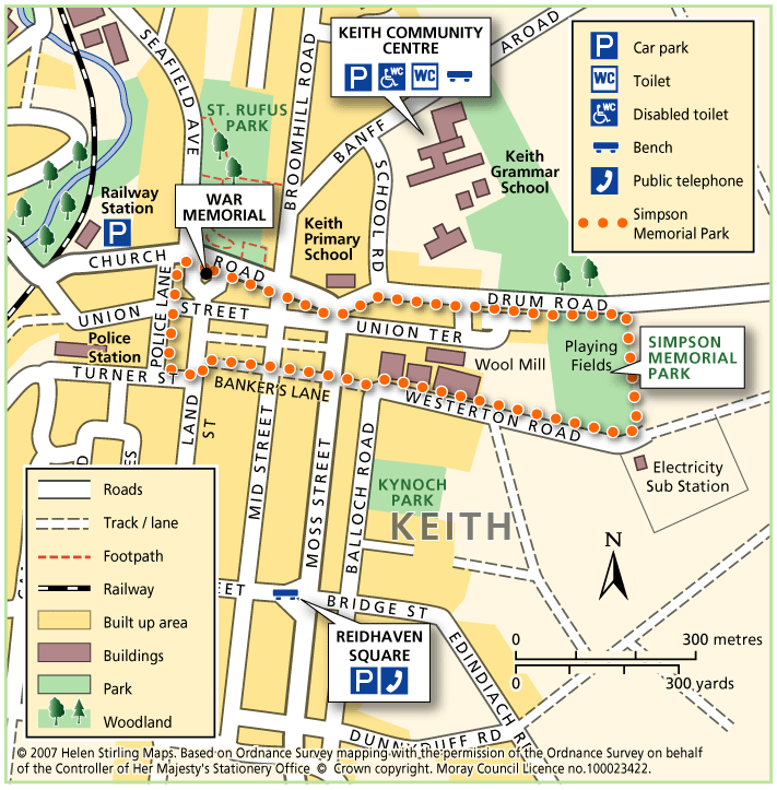
This is a circular walk which takes you round Simpson Memorial Park. It is mostly on pavements and good paths, apart from a short stretch of grass path which could be muddy in the wet. It is suitable for wheelchairs and buggies if dry and is fairly flat apart from the section along Drum Road.
- Accessible Walk, Health Walk
- Easy / Level 2
- 1.25 miles (2 km)
- 25 minutes
- Keith
Accessibility: Accessible for all with care
Can be used by buggies and wheelchairs during dry weather.
Terrain: Varied surfaces
Mostly on tarmac pavements and paths. Grass path at Simpson park - which can be muddy in wet weather.
Gradient: Undulating
Long but steady climb up Drum Road. Relatively flat elsewhere.
Keith – St Rufus Park Circular
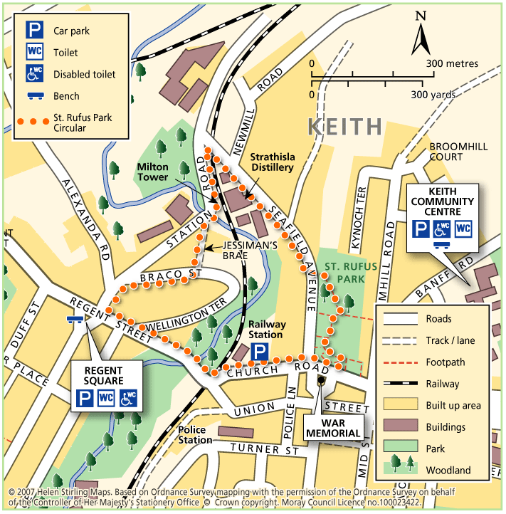
This circular walk includes some very interesting parts of Old Keith, Strathisla Distillery, Milton Tower and Keith and Dufftown Old Railway Station. There are some steep sections, which would make it unsuitable for wheelchairs. There are benches at the start and along the way.
- Health Walk
- Easy / Level 2
- 1.75 miles (2.8 km)
- 35 minutes
- Keith
- Unsuitable for wheelchairs and buggies
Terrain: Varied surfaces
A combination of roadside pavements, a tarmac footpath through the cemetery and a long section of gravel farm track. Take care on the track which is rather potholed and can be muddy in wet weather.
- Undulating
Keith – The Green Roadies
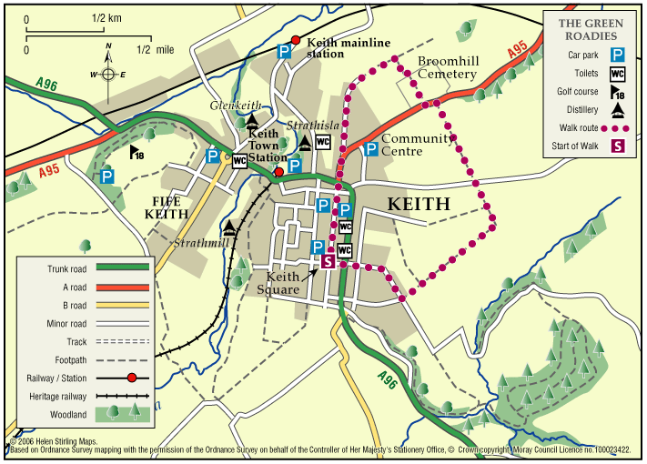
Enjoy the many different species of flowers, shrubs and birds that can be identified. Marvel at the fine views of all the surrounding hills that can be seen across green fields and farmland.
- Low Level Walk
- Easy
- 2.5 miles (4 km)
- 1h 30 minutes
- Keith
- Unsuitable for wheelchairs and buggies
Terrain: Varied surfaces
A combination of tarred roadside paths, minor roads, aggregate paths and rough grassy tracks. The grassy track sections, although flat, are muddy in places and can be difficult to negotiate.
Gradient: Generally level
A few gentle gradients in places.
- Fully signed
Knock Hill & Little Knockbog
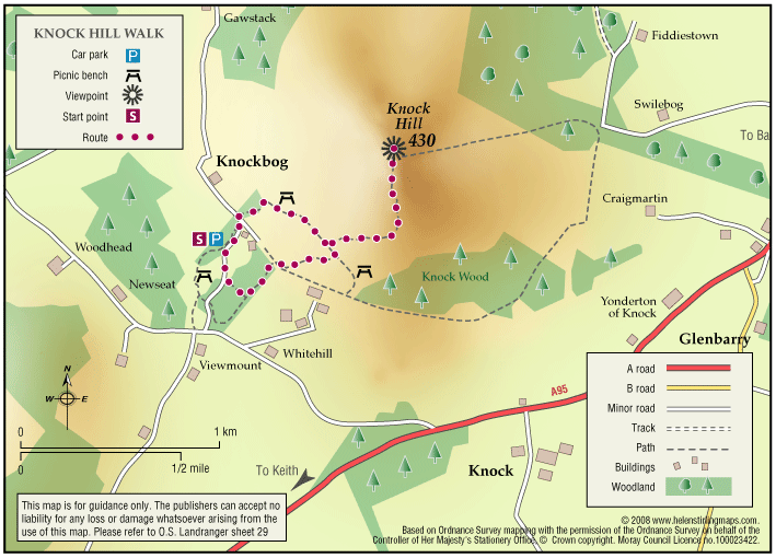
The starting point suggested is very overgrown and there is now “no right of way signs” placed. This is not a core path. There is potentially another route up via Swiebog. The car park is now closed for public use. If you have more information on this route or you would like to help maintain …
Lhanbryde – Circular
This circular walk is part of the Lhanbryde Paths Network. There are a variety of walking surfaces on this walk, including dirt paths, grass verges and pavements, which make it unsuitable for wheelchairs and buggies. There are also a few steps, which need caution.
- Health Walk
- Easy / Level 3
- 1.25 miles (2 km)
- 15 minutes
- Lhanbryde
- Unsuitable for wheelchairs and buggies
Terrain: Varied surfaces
A mixture of surfaces: pavements, grass, compacted earth and gravel paths.
Gradient: Short steep sections
Mainly level but some short sections of incline/ decline.
Lhanbryde – Crooked Wood and Urquhart
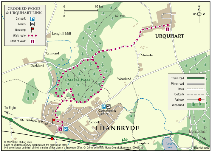
Located just a few miles east of Elgin, the woodland and countryside around the village of Lhanbryde provide a great opportunity for outdoor access.
- Low Level Walk
- Easy
- 2.25 miles (3.6 km)
- 1 hour(s)
- Lhanbryde
- Unsuitable for wheelchairs and buggies
Terrain: Varied surfaces
Informal earth path within the woodland, with several short steep sections. Generally dry but can be muddy in places, so stout footwear is recommended. There is a quiet section of public road between Crooked Wood and Urquhart.
Gradient: Short steep sections
Although generally level or gently undulating, there are some short steep sections, particularly within the woodland.
- Fully signed
Lhanbryde – Loch Na Bo Walks
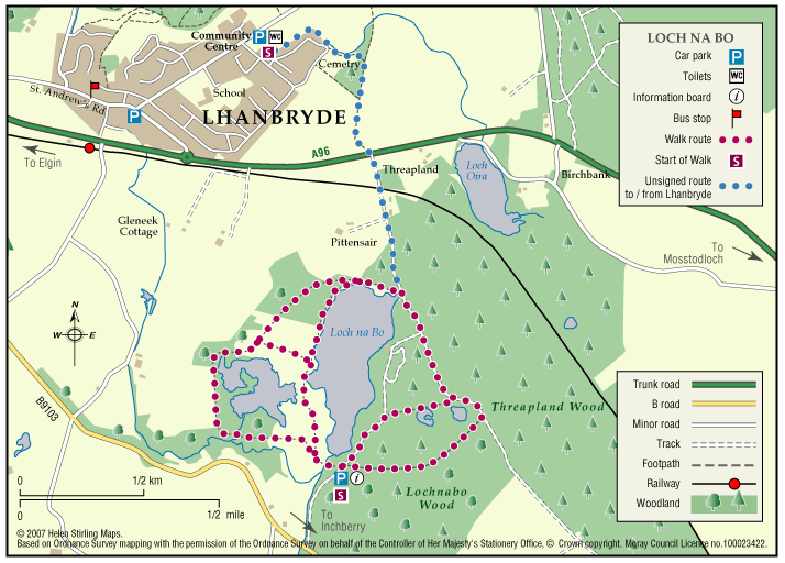
Located just a few miles east of Elgin, the woodland and countryside around the village of Lhanbryde provide a great opportunity for outdoor access.
- Low Level Walk
- Moderate
- 4 miles (6.4 km)
- 2 hour(s)
- Garmouth, Lhanbryde
- Unsuitable for wheelchairs and buggies
Terrain: Varied surfaces
Pavements, farm tracks and informal woodland paths (gravel and earth). Some paths can be muddy in places, so stout footwear is recommended.
- Generally level
- Partly signed
Loch Romach and Altyre Estate
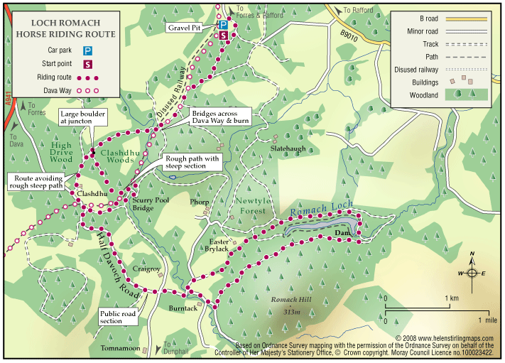
Views across the Cromarty Firth are magnificent from the High Drive on Altyre Estate. Some of this route follows the Dava Way which is way-marked but much is on private land.
- Horse Ride
- 7 miles (11.2 km)
- Forres
Logie – Dunearn Path
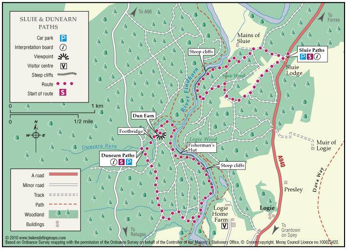
Dunearn path is in the Darnaway Forest and is about one mile south of Conicavel village, it is a circular route, part of which follows close to the River Findhorn. Be aware, the path in sections is very close to the edge of steep drops down to the river.
- Low Level Walk
- Easy
- 2.5 miles (4 km)
- 1h 30 minutes
- Logie
Accessibility: Suitable for a wide range of users
The route is suitable for a wide range of users but the terrain might prove difficult for the less able.
Terrain: Forest tracks
A mixture of woodland earth, aggregate and forest vehicle track. The path can be very wet and muddy in places, in winter time small sections of the path can be covered with leaves so making it very slippy.
- Fully signed
Logie – Estate Paths
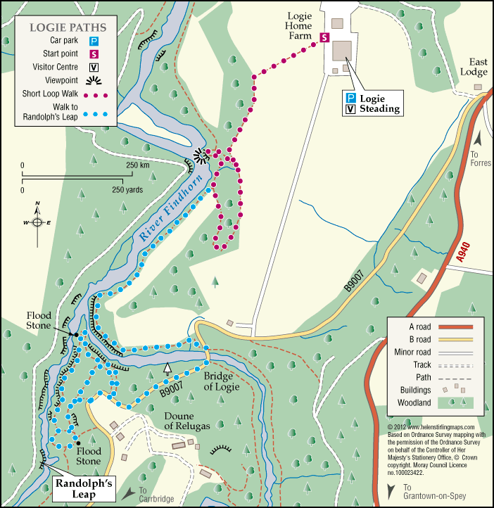
There are two dramatic river walks located on the Logie Estate within the beautiful Findhorn Valley, near the town of Forres. They start at the Logie Steading Visitor Centre, which houses the River Findhorn Heritage Centre, and has Arts and Crafts, Shopping, Walled Gardens, River Walks, an Adventure Playground and Café.
- Low Level Walk
- Easy
- 2 miles (3.2 km)
- Logie
- Unsuitable for wheelchairs and buggies
Terrain: Varied surfaces
The paths are narrow and steep sided in places.
- Fully signed
Logie – Sluie path
The path is a circular route through woodland, and the sections which follow the river Findhorn are very close to the cliff edge. The path is approximately three miles south of Forres.
- Low Level Walk
- Easy
- 2 miles (3.2 km)
- 1h 30 minutes
- Logie, Sluie
Accessibility: Suitable for a wide range of users
The route is suitable for a wide range of users but the terrain might prove difficult for the less able
Terrain: Forest tracks
Mostly a woodland earth path with narrow aggregate sections, and rough vehicle tracks.
Gradient: Undulating
Be aware the path is undulating and is close to steep cliffs at parts,
- Partly signed
Lossie Forest & Beach
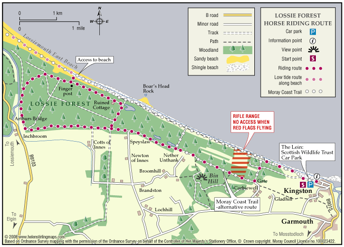
This ride takes you through the forest from Kingston towards Lossiemouth and back either through the forest or along the edge of the beach.
- Horse Ride
- 11 miles (17.6 km)
- Kingston
Terrain: Coastal tracks
Good firm sand on the beach and reasonably soft forest tracks.
- Generally level
Lossiemouth – Forest by the Firth Trail
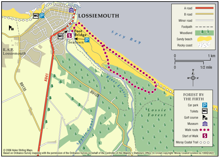
The town commands the prominent headland at the mouth of the River Lossie. It has dramatic and beautiful beaches, wonderful countryside and plenty to see and do. Part of the route follows the long-distance Moray Coast Trail.
- Low Level Walk
- Moderate
- 5 miles (8 km)
- 3 hour(s)
- Lossiemouth
Accessibility: Unsuitable for wheelchairs and buggies
Due to the loose sand and shingle, the route is unsuitable for wheelchairs, buggies or road bikes.
Terrain: Varied surfaces
The route follows the sandy beach, with areas of loose shingle, and forest tracks. The trail can also be damp through the salt marsh area. Sturdy footwear is advised.
Gradient: Generally level
Relatively level, except short steep shingle ridge of around 2 metres in height.
- Partly signed
Lossiemouth – Golf Course Walk
This walk takes you across the golf course to the beach look out and back. Buggies and wheelchairs can use the track with care. It has views of the Covesea Lighthouse and over the Moray Firth. It can be a little exposed if the wind is strong. Watch out for jets from RAF Lossiemouth overhead and keen golfers on the course!
- Accessible Walk, Health Walk
- Easy / Level 1
- 1 miles (1.6 km)
- 20 minutes
- Lossiemouth
- Accessible for all with care
- Varied surfaces
- Generally level
Lossiemouth – Harbour Circular Walk
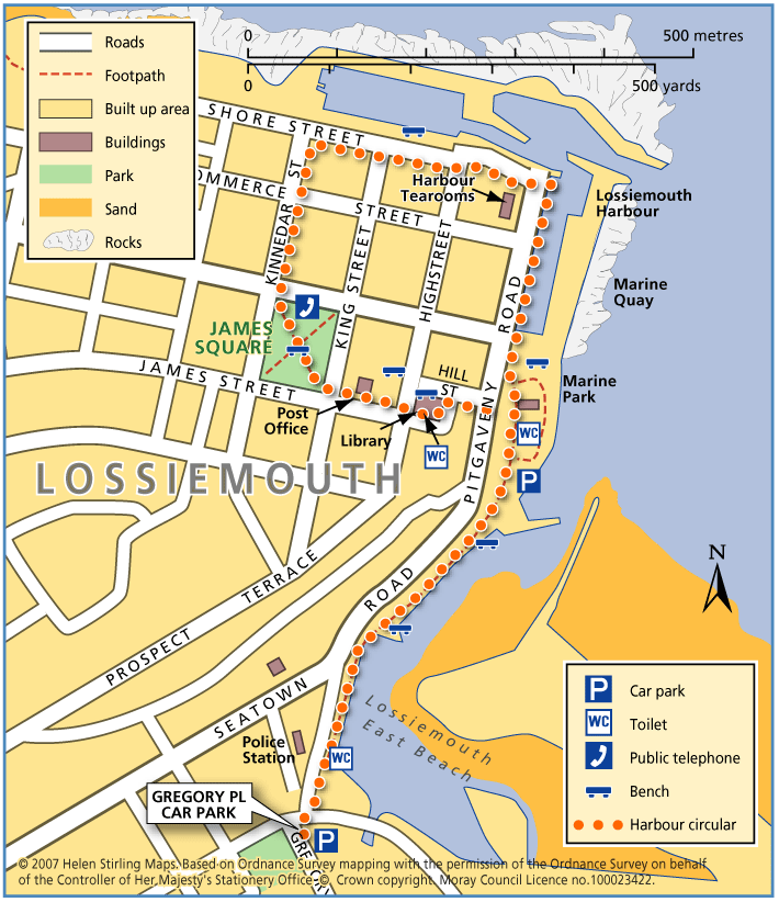
This is an extension of the Harbour Walk, up to James Square. It includes a small steep slope down Hill Street.
- Accessible Walk, Health Walk
- Easy / Level 2
- 1.25 miles (2 km)
- 25 minutes
- Lossiemouth
Accessibility: Accessible for all with care
Suitable for wheelchairs, with care on slope.
- Paved footpaths & roads
Gradient: Short steep sections
One short but steep section of decline.
Lossiemouth – Harbour Walk
This is a walk from Seatown to the Harbour and back again. It is all along good paths and is suitable for wheelchairs and buggies. It has lovely views of the East Beach and the boats in the harbour. There are toilets on Clifton Road, near the bakers and in Station Park, and benches along the way.
- Accessible Walk, Health Walk
- Easy / Level 1
- 0.5 miles (0.8 km)
- 10 minutes
- Lossiemouth
- Accessible for all users
- Paved footpaths & roads
- Generally level
Lossiemouth – Skerry Brae Walk
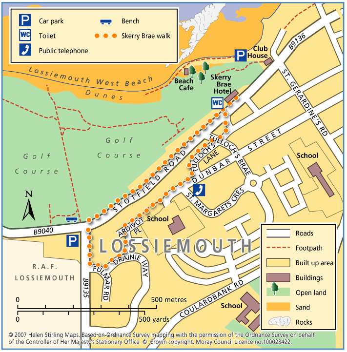
This is a circular walk on good footpaths and is suitable for wheelchairs and buggies. The route can be extended to include the Golf Course Walk, which would then be a Level 3 walk of 2 ¼ miles and take between 45 and 60 minutes.
- Accessible Walk, Health Walk
- Easy / Level 2
- 1.25 miles (2 km)
- 25 minutes
- Lossiemouth
Accessibility: Accessible for all with care
Suitable for wheelchairs and buggies, though be aware of the fairly steep section.
- Paved footpaths & roads
Gradient: Short steep sections
Fairly steep but steady decline at Tullochs Brae. Relatively level elsewhere.
Lossiemouth Loop
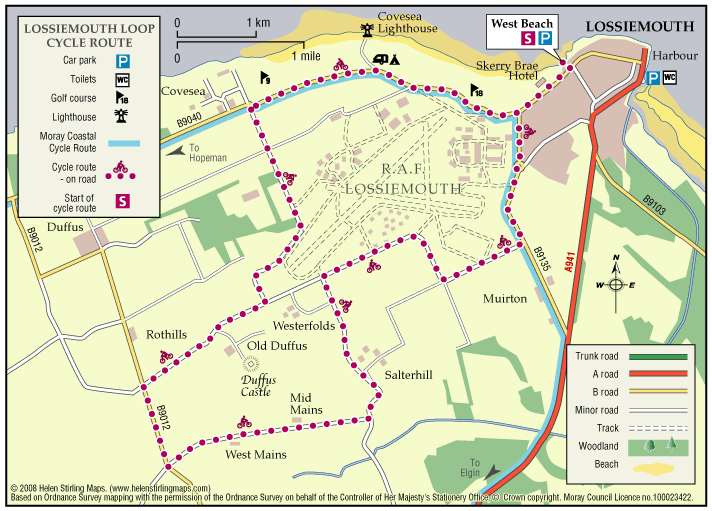
One of five Circular Cycle Routes in Moray, the Lossiemouth Loop takes you from the West Beach Car Park in Lossiemouth, round the perimeter of the airfield via Duffus Castle and back. The whole route is relatively flat and passes through fertile farming country.
- Cycle Route
- 14 miles (22.4 km)
- Duffus, Lossiemouth
- Paved footpaths & roads
- Generally level
- Fully signed
Moray Coastal Cycle Route
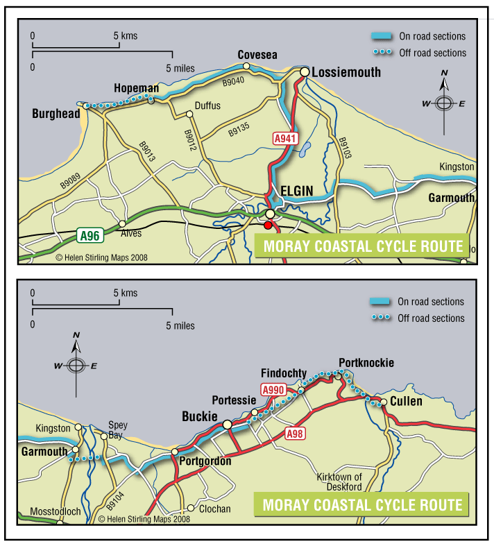
This is a signed cycle route from Burghead to Cullen, linking the coastal communities. Explore the dramatic landscapes from rugged cliffs to sweeping shores, sheltered coves to fishertown harbours. Visitors are drawn by the resident bottlenose dolphins and the myriad of birdlife on the cliffs.
- Cycle Route
- 29 miles (46.4 km)
- Buckie, Burghead, Elgin, Findochty, Garmouth, Hopeman, Lossiemouth, Portgordon, Portknockie, Spey Bay
Accessibility: Suitable for a wide range of users
Suitable for all types of bikes. Some sections are suitable for walking and horse riding.
Terrain: Paved footpaths & roads
Good surfacing through out, combining a mixture of gravel paths, tarmac paths, and public road sections.
- Generally level
- Fully signed